


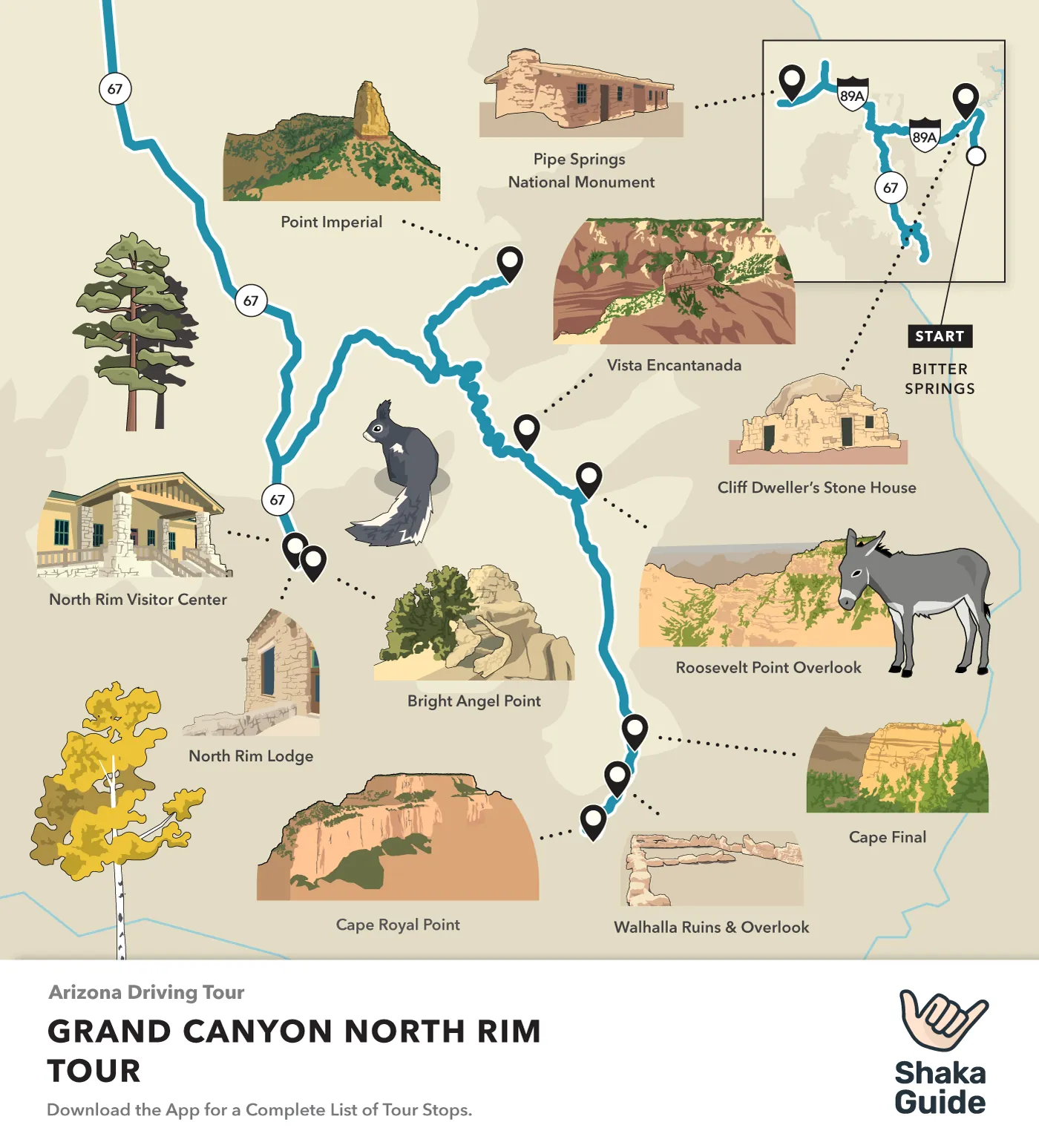
Shaka Guide's Grand Canyon North Rim Itinerary

*The Grand Canyon’s North Rim was impacted by the 2024 Dragon Bravo Fire. The North Rim is scheduled to reopen May 15, 2026, with services returning gradually. There will be no lodging available inside the park at reopening. Visitors should check the National Park Service website for the latest conditions and access updates.
Welcome to Shaka Guide’s Grand Canyon North Rim Tour!
The Grand Canyon's North Rim only sees about 500,000 visitors each season.
That's only about 10% of its more popular sibling, the South Rim.
This makes it the perfect place for peaceful pleasant hiking and serene sightseeing.
Since the North Rim’s main road is only open from mid-May to mid-October, we here at Shaka Guide want to make sure you see as much as possible while you’re here!
Below is our suggested itinerary for a truly memorable trip, but–as we always say–this is your adventure! We’re just along for the ride. So, let's get to it:
What’s the Best Itinerary for the North Rim?
Well, first of all, you gotta' decide where you'd like to kick off your trip. There are so many ways to get to the North Rim that Shaka Guide’s audio tour offers several different starting points depending on where you’re coming from.
Where to Start your North Rim Adventure:
- From Grand Canyon South or East Rims: Marble Canyon, AZ
- From Las Vegas: Arizona Highway 389 at Pipe Springs National Monument
- From Zion or Bryce Canyon National Parks (and all points North): US Highway 89 South in Kanab, Utah
Start from Marble Canyon
No matter where you begin, there’s plenty to see and do long before you reach the park gates. But for the first part of this itinerary, let’s say you’re starting in Marble Canyon, Arizona—a stunning slice of the Southwest where cliffs rise, the Colorado River winds below, and the Navajo Bridge marks the gateway to adventure. Then we'll show you the stops if you start from Kanab, Utah.
Ready? Let’s hit the road.
1. Navajo Bridge Interpretive Center

- Duration: Up to 1 hour
Constructed in 1927, the Navajo Bridge provided easier travel and trade access from Utah to Arizona across the Colorado River.
These days it's a historic landmark that you can walk across andmarvel at the river below.
2. Cliff Dwellers Stone House
 Alan English CPA from Scottsdale, Arizona 85254, USA, CC BY-SA 2.0, via Wikimedia Commons
- Duration: 15 minutes
Built by The Betsy and Bill Russel in 1927, this one-time makeshift shelter became a thriving lodge for travelers and a unique roadside attraction.
3. Dominguez Escalante Expedition Monument
 Bob Wick, Bureau of Land Management, Public domain, via Wikimedia Commons
15 minutes
Spanish priests Francisco Dominguez and Silvestre Escalante, explored this area in 1776. They were in search of a possible trade route from Mexico to California, and they may have been the first Europeans to see the Arizona Strip on their expedition in 1776
4. Vermillion Cliffs National Monument
 Bureau of Land Management, CC BY-SA 2.0, via Wikimedia Commons
- Duration: Up to a full day
Vermilion Cliffs National Monument is a vast wilderness area spanning nearly 300,000 acres.
While most drivers will choose to continue their journey straight to the North Rim, this stop marks the beginning of rugged 4-wheel drive routes leading to attractions like Wire Pass Day Hikes and the Condor Viewing Site.
5. House Rock Valley Overlook
 The Greater Southwestern Exploration Company from Claremont, California, United States, CC BY-SA 2.0, via Wikimedia Commons
- Duration: 10 minutes
You'll soon reach a scenic turnout offering a final breathtaking view of the Vermillion Cliffs and the House Rock Wildlife Area.
This stop provides a perfect opportunity to savor the rocky landscape before we transition into the lush Kaibab National Forest, marking a dramatic change in elevation and environment.
Start from Kanab
6. Pipe Spring National Monument (Fredonia, Arizona)
 National Park Service Digital Image Archives, Public domain, via Wikimedia Commons
- Duration: 1 to 2 hours
The National Park Service's website, sums this unique national monument best: "The rich history of Pipe Spring and its flowing water comes alive as you explore the traditions of the Kaibab Paiute and the Mormon settlers through the museum, historic fort, cabins, and garden.
Hike the Ridge Trail to enjoy geologic wonders, plants, and wildlife. Attend living history demonstrations and talks and be sure to visit with our amazing ranch animals!
7. Kanab Visitor Center
 Frank Em
- Duration: 1 to 2 hours
One of the four visitor centers within the Grand Staircase Escalante National Monument.
The Kanab Visitor Center focuses on the geology and archeology of the Grand Staircase Escalante National Monument.
8. Le Fevre Overlook
- Duration: 5 minutes
There’s only one stop for visitors coming from Fredonia before they arrive at Jacob’s Lake, and that’s the Le Fevre Overlook.
This roadside stop looks out at the red-orange bands of the Grand Staircase Escalante. There’s even binoculars so you can admire the staircase with a better, closer view!
All Together Now
From here on, all the stops are the same. And we've got some great ones.
9. Jacob Lake Inn
 National Archives and Records Administration, Public domain, via Wikimedia Commons
- Duration: Up to 1 hour
A great option breakfast, lunch or dinner! The Jacob Lake Inn offers several dining options and a world-famous bakery! Want to book a stay, and sleep just on the edge of the Kaibab National Forest? Book at their website here.
Writer's Tip: Get a giant cookie. In fact, get like 5. And feel free to thank me later.
10. Jacob Lake Lookout Tower
This 80’ Aermotor steel tower with a 7’ x 7’ metal cab was built by the Civilian Conservation Corps in 1934 and used by wildland firefighters and rangers to spot far-off wild fires. It was decommissioned in the 1970s but is still open to visitors.
11. North Rim Country Store
 Kaibab Lodge
- Duration: Up to 1 hour
The Country Store is a great place to load up on supplies, snacks, and gas before going out to hit the trails.

12. Point Imperial Road
 Daniel Schwen, CC BY 3.0, via Wikimedia Commons
- Duration: 1 to 4 hours
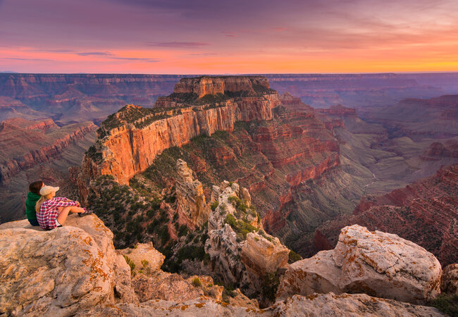
Point Imperial has the distinction of being the highest point on the North Rim. At 8,803 feet above sea level, you'll be able to see Boundary Ridge and its central peak Saddle Mountain to the North.
The Nankoweap Trail runs across the lower ridge, and views of Mount Hayden, Hancock Butte, and Alsap Butte are visible from the upper part of the ridge.
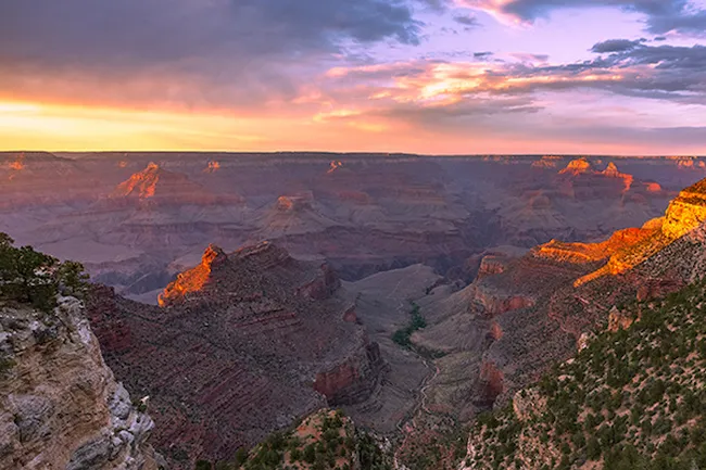
13. Vista Encantada
 Shutterstock Image
A quiet viewpoint along Cape Royal Drive, Vista Encantada is a picnic area that's blanketed in wildflowers and offers views of Nankoweap.
The viewpoint of Vista Encantada looks out over the Walhalla Plateau. On clear days, you may be able to see the Painted Desert in the east.
14. Roosevelt Point Overlook
 Miguel Hermoso Cuesta
Another viewpoint along Cape Royal Road. Roosevelt Point is accessed through a very short walk and has resting benches.
Despite the high ridge, much of the northern scenery is visible, including the farthest section of the Grand Canyon.
Here, the Colorado River carves a narrow gorge just a mile wide, slicing through the flat desert plain between the Vermilion and Echo Cliffs.
15. Cape Final Trailhead
 Grand Canyon National Park, CC BY 2.0, via Wikimedia Commons
This is a 4-mile out-and-back trail leads to Cape Final. The trail is rated easy, which means it's relatively flat and shaded.
The first part of the trail winds through the Ponderosa pine forest until you get to Cape Final Overlook, which provides expansive views of the North Rim.
Many people say that this is the best overlook on the North Rim.
16. Walhalla Ruins
 Grand Canyon National Park
The Walhalla Ruins--or Walhalla Glades--was once the summer home of the Basketmakers during the Pueblo period.
Here you'll be able to tour 10 rooms that have been left behind, and attend ranger-led talks and tours through the artifacts!
17. Walhalla Overlook
 Krzysztof Ziarnek, Kenraiz
The Walhalla Overlook is just across the road from the Ruins. Here, you'll be treated to views of the Echo Cliffs, the Painted Desert, and the Little Colorado River Gorge.
18. Angel's Window
 Grand Canyon National Park
Angel’s Window Viewpoint is a great place to get a wide-angle photo of the stone arch. If you wanna check it out, then park in the pullover on your left.
19. Cape Royal Point
This is the southernmost viewpoint at the North Rim, and it offers the most expansive views. In fact, you'll get an almost 270 degree view of the entire horizon.
See if you can spot Angel's Window, a natural arch in the Kaibab limestone which frames a little section of the Colorado River
20. Point Sublime
- Duration: 4 hours
WARNING: Point Sublime is hard to access and pretty remote, so please don’t attempt this drive without a high-clearance, 4x4 vehicle.
This is the westernmost viewpoint at the North Rim (accessible by car, that is), but many wildfires have burned through this area and sometimes the access road is closed because of this.
It takes about 2 hours to actually get to Point Sublime, and the National Park calls the road “primitive.”
In fact, a backcountry permit is required if you plan on camping here.
So what’s the point of even trying, you ask?
Legend has it that the view from Point Sublime is one of the most breathtaking, awe-inspiring views of nature’s majesty that you’ll ever see.
If you’re up for the challenge (and are completely sure that you’re prepared for the journey), have a great time and please, tag us in your photos! (@shakaguide, in case you forgot).
21. Widforss Trailhead
 Miguel Hermoso Cuesta
Named for artist Gunnar Widforss, this trail is a long one, ut a flat one. It's 10 miles of relatively flat trail.
The first part is slightly uphill through forest. It will then follow the rim of the canyon before dropping down into the valley and then to a final plateau for the best views.
22. Uncle Jim Trail
 John Manard
The Uncle Jim Trail is a moderate 4.7 out-and-back trail that leads to the Uncle Jim Trail Overlook and views of the canyon.
This trail has several uneven points and is a popular trail for guided mule rides, so watch your step!
23. Bright Angel Point
 Wolfgang Staudt from Saarbruecken, Germany
This is the most visited viewpoint on the North Rim! Bright Angel Point can be accessed behind the Lodge on the Transept Trail.
This is only a half-mile, paved path that leads to the Point, where you'll be treated to view of three peaks named for three Hindu deities:
- Deva Temple,
- Brahma Temple and
- Zoroaster Temple.
24. North Rim Visitor Center and Lodge
 Daniel Schwen
Plenty of parking here! The North Rim Visitor Center also offers educational programs, interactive exhibits both indoor and outdoor, a large gift shop, ranger information stations, and those all-important restrooms, too!
Writer's Tip: Staying at the North Rim Lodge is a dream for most people who come this way. But, you'll need to make those reservations early if you hope to snag a room.
Final Thoughts
Fresh-baked sweets, heart-pounding lookouts, and soul-soothing viewpoints. What are your number one choices for you North Rim trip?
For us? Grabbing some homemade goods from Jacob's Lake Inn, picking a quiet spot along the rim, and relaxing with a picnic lunch are peak North Rim vibes. Up at the North Rim, things are a little quieter, a little more still, and a whole lot more tranquil. And really, that's just how we like it.

Jess Conaway is a small-town mom and former theater kid who grew up exploring the Gettysburg Battlefield, and she’s been a history buff ever since. Jess has a passion for preserving our nation’s stories, but she especially loves discovering the human history of the places she visits—the weirder, the better!
She’s also not ashamed to admit that she cried the first time she saw the sun rise over the Tetons.
Like this article? Share it on Pinterest!

Excited to embark on your adventure? Be sure to take Shaka Guide along for the ride, with our Grand Canyon North Rim tour.
We hope that we’ve given you all the information you need to make the most of your day. Your vacation is extremely important to us so if you have any questions feel free to reach out at aloha@shakaguide.com.
For more detailed information to help you plan, check out our Grand Canyon North Rim Know Before You Go article.
RELATED:
Know Before You Go: Shaka Guide’s Grand Canyon North Rim Tour
Death Valley National Park Itinerary
Flagstaff to Grand Canyon North Rim: 7 Stops Along the Way


 to fuel your ride
