- Start each park day early to avoid parking congestion, long shuttle lines, and peak mid-day heat.
- Secure required timed entries and permits in advance—Arches and Angels Landing often sell out quickly.
- Download offline maps and pack plenty of water, layers, and sun protection since weather and service vary.
- Choose lodging near each park—Hurricane, Bryce Canyon City, Torrey, and Moab minimize long daily drives.
- Expect long drives between parks, so plan fuel, food stops, and restroom breaks before entering remote areas.
TABLE OF CONTENTS
- Itinerary Overview
- Entry Fees, Reservations & Hiking Permits
- What should I pack for a Utah road trip?
- What is the Best Time to Visit the Mighty 5?
- Where should I stay along a Mighty 5 road trip route?
- Frequently Asked Questions
Oh my, oh my—to see the Big Five. Utah is a full-blown mecca for national park enthusiasts, and it more than earns that title.
Craggy spires, red rock cliffs, sandy deserts. Slot canyons, rushing rivers, stone arches…I could go on forever.
Each of the 5 parks brings something different:
- Zion goes vertical, with sheer canyon walls and river-carved narrows.
- Bryce Canyon trades scale for detail—thousands of high-elevation hoodoos.
- Capitol Reef is quieter and layered with cliffs, domes, and history.
- Arches delivers Instagram-worthy icons on repeat.
- And Canyonlands shows you just how grand the desert really is.
Together, they make up Utah’s Mighty 5—five distinct parks, one unforgettable road trip.
This itinerary strings them together in a logical loop, balancing drive days with park time so you’re not rushing the highlights or burning out halfway through.
It’s a whirlwind, yes—but absolutely doable, and absolutely worth it.
Itinerary Overview
Just a heads-up: this itinerary follows a west-to-east route, coming in from St. George or Las Vegas. But don’t worry—the Shaka Guide audio tours work both ways. Feel free to customize your itinerary as you see fit.
Oh, and quick mention: a few things on this itinerary need reservations. Namely:
- The Angel’s Landing Hike in Zion National Park
- The Fiery Furnace hike in Arches National Park, and
- entry to Arches National Park.
Book them all on recreation.gov.
Day 1 - Finding Zion National Park

Your first day will be jam-packed, so I recommend finding lodging the night before in Hurricane.
It’s more affordable than Springdale, still close to the canyon, and there’s plenty to see on the way to the park the following morning.
Today, we’ll hit all the major park highlights in the famous Zion Canyon. Be aware that you’ll need to leave your car behind after parking in Springdale.
Shuttle rides only during the high season, no personal vehicles allowed. More details can be found here.
Be sure to head out early to get the best parking spot in Springdale.
1. La Verkin Overlook
 Rachel Ennis
- Approximate time: 15 minutes
At La Verkin Overlook, you’ll get a beautiful panoramic view of Zion Canyon, the Virgin River Gorge, Pine Valley mountains, and, of course, La Verkin itself.
To get there, you’ll take a 15-minute round-trip drive down a bumpy gravel road. But hey, sometimes, the journey is half the adventure.
2. Grafton Cemetery
 Rachel Ennis
- Approximate time: 10 minutes
At Grafton Cemetery, you’ll find the resting places of early pioneers alongside members of the local Native American community.

3. Grafton Ghost Town
 Rachel Ennis
- Approximate time: 15 minutes
Grafton is a ghost town with a history that sets it apart. While most abandoned settlements in the West were mining towns—rising fast and falling just as quickly—Grafton was rooted in agriculture.
Today, visitors can explore the old homes, some still standing strong enough to step inside, and get a feel for what life was like in this once-thriving pioneer community.
4. Zion Canyon Visitor Center
 Rachel Ennis
- Approximate time: 45 minutes
At the Zion Canyon Visitor Center, you can pick up trail maps, browse the bookstore, and refill your water bottles.
If you're planning any backcountry camping or canyoneering, this is also where you'll need to get your Wilderness Permits.
The turnoff is just past the entrance gate—look to your right.
5. Pa'Rus Trail
 John Manard
- Approximate time: 1 hour
Does the shuttle line look a little... daunting? Here’s a pro tip: just skip it.
All you need to do is take the sunny Pa’rus Trail from the Visitor Center to the Human History Museum and hop on the shuttle there—no waiting required.
This is the only trail in Zion where you can walk your dog or ride a bike, and it’s fully paved. That said, it’s 1.7 miles one way, so it’s not ideal for everyone.
Follow the signs at the Visitor Center if this sounds like your kind of detour.
6. Zion Human History Museum
 Don Graham from Redlands, CA, USA
- Approximate time: 30 minutes
Step inside to explore over 300,000 artifacts, specimens, and pieces of art that tell Zion’s story.
Need a break to beat the heat? Catch the free 22-minute film about the park—or better yet, head to the shady back patio for a Ranger talk. These expert-led sessions dive into topics like geology, wildlife, and more, each with its own unique flair.
You might even catch a guided ranger walk or hands-on activity. For the latest schedule, check in at the Visitor Center.
7. Court of the Patriarchs
 au_ears
- Approximate time: 10 minutes
These three striking, white-capped peaks form the Court of the Patriarchs. From left to right, you’ll see Abraham, Isaac, and Jacob—named after the patriarchs of Judaism.
It was Methodist minister Fred Fisher who gave them these names, hoping to reflect the awe and reverence these cliffs inspire.
This is a quick roadside stop, so feel free to hop off, snap a photo, and take in the majesty of the Court up close.
8. Zion Lodge and Emerald Pools
 Rachel Ennis
- Approximate time: 2 hours
Zion Lodge is the only place in the park where you can grab something to eat, and the shady cottonwood tree makes this the perfect picnic stop.
Not hungry? You can also stop here to use the restroom and refill your water bottles before heading out.
Zion Lodge is also the most commonly used entrance to the Emerald Pools Trail--an extremely popular trail that's family-friendly. If you’re lucky and the conditions are just right, you may be treated to sparkling, emerald-green water beneath the twinkling hanging gardens.
If you only hike to the Lower Pool, you’ll follow a short, paved path about a half mile long starting from the Zion Lodge. If you prefer a longer, unpaved trail, enter at The Grotto, one stop down the road. Round-trip distances are:
- 1.2 miles to lower,
- 2 miles to the middle and
- a whopping 3 miles to the upper pools
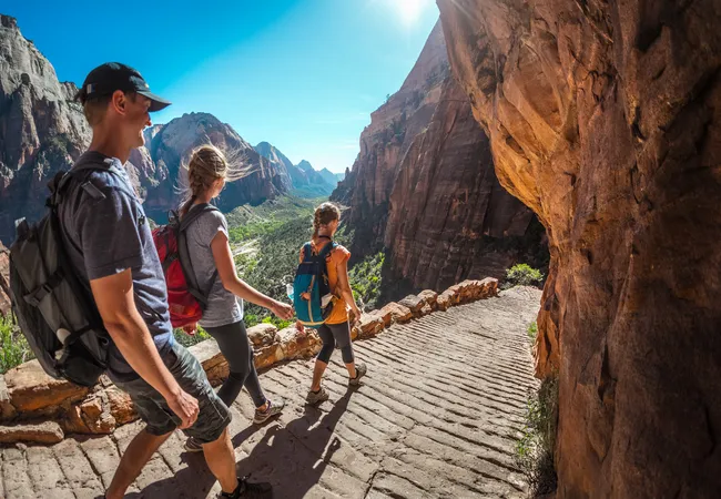
9. The Grotto and Angel's Landing
 Nicolas Vollmer from Munich [Allemagne]
- Approximate time: 4 hours
Thinking of hiking Angel’s Landing? You’re not alone. I mean, really not alone.
In fact, so many people wanted to hike Angel's Landing that starting in 2022, the National Park Service began requiring a permit, handed out via lottery.
Yep—you now need to win the right to terrify yourself.
Check the Zion National Park website for the latest details.
Now, let’s talk trail.
At its most infamous point, the path narrows to just a few feet, with sheer drop-offs on either side. Chains are bolted into the cliff to hang onto—so if your palms are already sweating, no shame in stopping short.
Good news, though:
The trail up to Scout Lookout doesn’t require a permit. And while you'll still need to conquer Walter’s Wiggles—a series of 21 tight, relentless switchbacks with an aggressively cheerful name—the rest of the trail is paved and very doable with a bit of stamina.
Scout Lookout offers a killer view of Angel’s Landing without the death-defying finale. It’s a win-win for folks who like their hikes with a side of oxygen and dignity.
You’ll find the Angel’s Landing trailhead just past the Grotto Bridge. Refill your water bottles at the shuttle stop—hydrated hikers are happy hikers.
10. Great White Throne, Weeping Rock, and Observation Point
 John Dahlstet
- Approximate time: 4 hours
Around 800 A.D., by rain and snow, water began working its way through the layers of what we now call “Weeping Rock.”And for over 1,000 years, that water percolated downward before encountering the impermeable Kayenta Formation.
Forced to move horizontally, the water diffused out of the soft limestone, washing away the formation as it went, and creating the alcove known as Weeping Rock.
There are also two very popular but very challenging hikes here.
1. Observation Point
Craving a view that makes Angel’s Landing look downright average? Head for Observation Point—the highest easily accessible viewpoint in Zion Canyon.
It's a strenuous 8-mile round trip via the East Mesa Trail, with serious elevation gain. Translation: this hike isn’t messing around. If you’re up for the challenge, follow the East Mesa Trail until it splits toward Observation Point. There, you can claim your reward... sweeping, panoramic views—and, of course, bragging rights.
2. Hidden Canyon Trail
Shorter, but no less dramatic. Hidden Canyon is just over 2 miles round trip, but don’t let that fool you. It’s steep, exposed, and not for anyone with a fear of heights.
Along the way, you’ll be treated to dizzying vistas, a free-standing arch, and a tucked-away slot canyon that feels like Zion’s best-kept secret.
Give yourself extra time—it’s slow going in spots, especially if your legs start questioning your life choices.
Note: As of 2019, this stop is closed due to a rockfall. No re-opening date is released as of this writing in 2025.
11. Temple of Sinawava, Narrows, and Riverside Walk
 Rachel Ennis
- Approximate time: 2-4 hours
This stop marks the start of several great hikes, including one of Zion’s most iconic—The Narrows. In places, the canyon walls squeeze in to just 9 meters (30 feet) apart.
It’s my personal favorite hike in the park, hands down. And if you're hot-natured like me, wading through cool canyon water might just make it your favorite too.
The water can get as high as your thighs, so come prepared! There’s no official endpoint—just hike upstream as far as you’d like, then turn around when you’re ready.
The bottom-up hike from the Temple of Sinawava does not require a wilderness permit and is a fun, cooling trip through the slot canyon up the Virgin River. Just be sure not to go past Big Springs unless you have a permit. It’s about three miles to “Wall Street,”-the section of the canyon where the walls begin to narrow.
But, let's say you don't have time for The Narrows...or, maybe, you just don't want to get wet. Understandable. Just turn around after completing the highly recommended Riverside Walk.
This two-mile paved and accessible trail is appropriate for visitors of all fitness levels. As you walk along the hanging gardens, be on the lookout for Zion Snails. These tiny, pinhead-sized black snails can only be found along the weeping walls here and nowhere else in the world! See if you can spot them!
One last note: the river water is not considered potable due to the presence of cyanobacteria. So, before heading in, be sure to fill up your water bottle and use the restroom.
12. Take a Well-Earned Rest
- Approximate time: 1-2 hours
Now, our day is done, and it’s time to head out of the canyon. Grab a bite in either Springdale or Hurricane on your way through before collapsing into bed in Hurricane.
Day 2 - East Side of Zion
This day is all about seeing some of the “other sides” of Zion.
First, we’ll head to Kolob Canyons, on the far northwest corner of the park. After a quick drive and hike, we’ll head down State Route 9 to check out East Zion before continuing on to our lodgings in either Bryce City or Kanab.
If you’re wrapping up some things from the day prior or need a little time to rest, it’s okay to skip down to number 5, the Great Arch Viewpoint.
Note: While food options are more limited, Bryce City is much closer to Bryce Canyon National Park and will save you a long day of driving. On the other hand, Kanab is full of fun things to see and do–well worth a day on its own.
Kolob Canyons
1. Kolob Canyons Visitor Center
 Rachel Ennis
- Approximate time: 20 minutes
As you pull in, be sure to check in at the Kolob Canyons Visitor Center to show your park pass.
2. Taylor Creek Trail
 Image from Flickr by Jack Miller
- Approximate time: 3 hours
The first trail you’ll pass will be Taylor Creek Trail, a 5-mile round-trip hike with several unique sights. The Fife and Larson cabins—the first homes built in Kolob Canyons—can be found here, as well as a double arch.
For those of you who love history, follow the trail to the end to find the waterfall used by Mountain Meadows Massacre perpetrator John D. Lee during his hideout from the law.
3. Horse Ranch Mountain
- Approximate time: 5 minutes
As you pass the Taylor Creek Trailhead, cast your eyes ahead and slightly to the left. You’ll see a summit towering over three small finger canyons. That towering summit is Horse Ranch Mountain—the highest peak within the park’s boundaries.
The three finger canyons—Tucupit, Paria, and Beatty points, from left to right—are stunning. You'll definitely want to use one of the pull-offs to stop and appreciate them further.
4. Timber Creek Trail and Kolob Overlook
 Rachel Ennis
- Approximate time: 1 hour
The Timber Creek Trail marks the end of the road here in Kolob Canyon, and it’s a highly recommended stop. It’s only a one-mile round-trip hike, and even though it's an uphill walk on the way to the overlook, it’s all downhill from there!
When you reach the top, look east to Shuntavi Butte at the base of Timber Top Mountain.
East Zion
5. Great Arch Viewpoint
 James St. John
- Approximate time: 10 minutes
When an arch is not freestanding, it's called a “blind arch.” Zion's blind arch can be seen along the roadway or at several pullovers along its serpentine road. Just safely swing in and snap those pictures.
6. Canyon Overlook Trail
 Rachel Ennis
- Approximate time: 1 hour
This 1-mile hike comes highly recommended—by just about everyone. And especially by me. It leads to a stunning viewpoint overlooking the rugged beauty of East Zion.
The trail is moderate in difficulty, but expect a bit of adventure: you’ll cross slickrock and pass near some steep drop-offs. Despite the name, slickrock isn’t actually slippery—unless it’s wet from rain or snow.
If you want to check out Canyon Overlook Trail, after the tunnel, just pull into the first turnouts. If they’re full, then just continue driving until another pull-off, then walk back to the trailhead.
7. Checkerboard Mesa
 Rachel Ennis
- Approximate time: 10 minutes
Best viewed from a distance, the white sandstone bears criss-crossed or “checkerboard” bands on its face.
While the Checkerboard Mesa Canyon trail begins a little further westward, the best viewpoint is a little further east, towards the far-end of the park, just past the mesa.
8. East Ranger Station
 Clayton B. Fraser
- Approximate time: 5 minutes
Interested in exploring even more of East Zion? At the Ranger station, you’ll have access to several famous hiking trails, including Observation Point, the highest lookout in Zion.
Since the rockslide has currently closed the route via East Mesa, as of 2025, this is the only way to reach Observation Point.
If you're interested in history, the East Rim Trail offers views of the remnants of the Cable Mountain Draw Works, an early 1900s pulley system once used to lower timber into the canyon.
These trails are long, rugged, and interconnected, so be sure to check trail conditions, maps, and current access with a ranger before heading out.
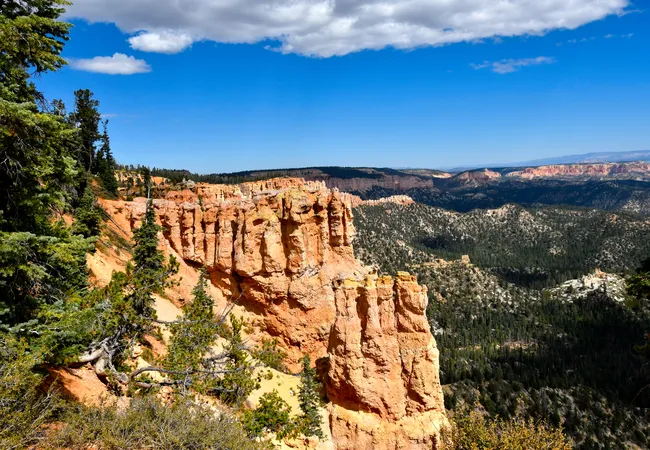
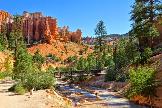
Day 3 - Big Day in Bryce Canyon
Bryce Canyon National Park is divided into two main areas: the Bryce Amphitheater and the Scenic Drive.
With Shaka Guide, you have the option of which you’d like to experience first. In this itinerary, we’ll start with the scenic drive.
However, if you’re short on time, you can skip the scenic drive and head to Bryce Amphitheater first…but we highly recommend you visit both!
1. Bryce Canyon City
 I, Luca Galuzzi, CC BY-SA 2.5, via Wikimedia Commons
Approximate Time: 5 minutes to 2 hours
This is the main road into Bryce Canyon National Park, and there’s no lack of activities here!
Bryce Canyon City is home to Ruby’s Inn, which has been around since the early 1900s. Ruby’s isn’t just a hotel, though.
Ruby’s has several properties:
- a general store
- three restaurants
- an “old town” mini-mall with gift shops
- an ice cream parlor, and
- a working gem mine!
They also offer many unique ways to see the park:
- horseback riding tours
- guided ATV tours
- bike rentals, and
- even helicopter rides
2. Bryce Canyon National Park Welcome Sign
Approximate Time: 5 minutes
Start your adventure by stopping at the official Bryce Canyon National Park Welcome Sign for a leg stretch and an Instagram-worthy selfie!
3. Fairyland Point
 Ronnie Macdonald from Chelmsford, United Kingdom, CC BY 2.0, via Wikimedia Commons
Approximate Time: 10 minutes
Here you’ll get a first look at the famous hoodoos of Bryce Canyon. You’ll learn how they’re formed, how they got their name, and the important role they play in the conservation efforts of the national park system.
4. Entrance Gate and Visitor’s Center
Approximate Time: About 1/2 hour
After you pass through the front gate, be sure to check out the Bryce Canyon Visitor’s Center.
Here you’ll have the opportunity to explore the small museum and learn more about the geology and cultural heritage of Bryce.
Be sure to check out the award-winning 20-minute film “Shadows Through Time” and the large gift shop!
On your way out, check in with the friendly park ranger staff about the many educational talks and tours they offer daily
Bryce Canyon Scenic Drive
This is a wildly popular way to see everything that Bryce Canyon has to offer.
The scenic drive will take you 18 miles to Rainbow and Yovimpa Points; the southernmost but highest points of Bryce Canyon.
Along the way, you’ll have the opportunity to hear more stories of the people who discovered Bryce Canyon and championed it to become a National Park.
On the way back, we’ll stop at the other 7 viewpoints:
- Black Birch Canyon
- Ponderosa Point
- Agua Canyon Viewpoint
- Natural Bridge Viewpoint
- Farview Point
- Piracy Point, and
- Swamp Canyon
From these viewpoints, you’ll not only see hoodoos but also other unique rock formations in brilliant colors, flora, and fauna that make up the rest of Bryce Canyon. The Scenic Drive is a nature lover’s dream!
After you’ve completed the scenic drive, we’ll make our way to the Bryce Amphitheater, or you can skip the scenic drive altogether and head straight to Bryce Amphitheater - the choice is yours.
5. Rainbow and Yovimpa Points
Approximate Time:10 minutes
Rainbow and Yovimpa Points are within walking distance of one another and share a large parking area.
Rainbow Point is actually the highest point in the park at 9,100 feet above sea level.
You’ll be able to see most of Bryce Canyon from here, and on a clear day, you might be able to see all the way to the Grand Canyon, which is over 300 miles away!
After taking in the breathtaking views from Rainbow Point, take a very short, paved walk over to Yovimpa Point to see even more layers of the Grand Staircase.
6. Bristlecone Loop Trail
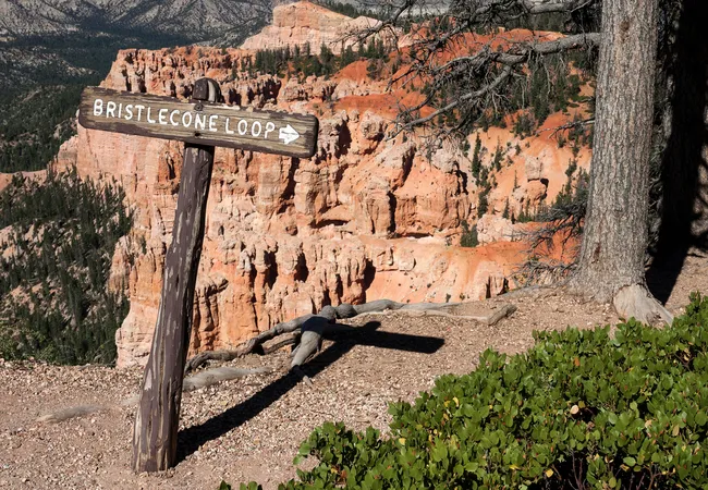 Shutterstock Image
Approximate Time: 45 minutes
This is the first of X recommended hikes on the tour, but it’s an easy one with minimal incline.
Bristlecone Loop Trail is one mile long and will take you through a forest of Bristlecone Pine trees, which are some of the oldest trees in the entire world.
7. Black Birch Canyon
 Shutterstock Image
Approximate Time: 10 minutes
Stop by Black Birch Canyon Viewpoint to get a look at the spectacular Ponderosa Pine trees and the Navajo Mountains looming in the distance.
8. Ponderosa Point
Approximate Time: 5 minutes
Another great viewpoint of the forest areas of Bryce Canyon and the large, hulking Ponderosa Pine trees.
9. Agua Canyon Viewpoint
Approximate Time: 10 minutes
You’ll get a great view of some of the more well-known hoodoos at Bryce Canyon from here.
Keep your eyes peeled for the Backpacker and the Rabbit, and see what other shapes your brain can come up with!
This is also a great viewpoint to take photos of Thor’s Hammer, the most famous hoodoo.
10. Natural Bridge Viewpoint
 Bernard Spragg. NZ from Christchurch, New Zealand, Public domain, via Wikimedia Commons
Approximate Time: 10 minutes
Stop by the Natural Bridge viewpoint and experience firsthand the power of the elements!
This bridge was shaped completely by Mother Nature, and it’s truly magnificent to behold.
11. Farview and Piracy Points
Approximate Time: ½ hour
These two viewpoints are within easy walking distance of one another. At Farview Point, the air quality is so pure that you’ll be able to see clear into Arizona!
Keep an eye out for the colorful rock formations and breathtaking views of the far-off Navajo Mountain.
Then take an enchanted walk through the path to Piracy Point, which is unofficially known as the Hansel and Gretel trail.
Weave through sun-dappled Ponderosa and Bristlecone Pines, and keep an eye out for squirrels and songbirds!
Once you get to Piracy Point, take a look into the distance and see if you can spot the cliff formation that looks just like Blackbeard’s ship!
12. Swamp Canyon
Approximate Time: 10 minutes to 3 hours
Swing by Swamp Canyon and take a look at one of the only viewpoints in the park that has its own natural water source.
Because of this, the vegetation is green and lush all around the hoodoo formations here.
If you’re an experienced hiker, you may want to try out the Swamp Canyon Loop Trail here; it’s a 4.5-mile hike that descends into Swamp Canyon and connects to the Under-the-Rim Trail before looping back around.
If you’re not prepared to take such a strenuous hike, hang out at the top of Swamp Canyon and keep an eye out for California Condors overhead.
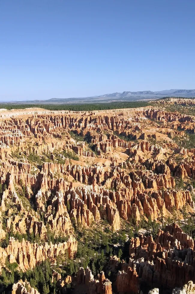
The Bryce Amphitheater
 Fabio Achilli from Milano, Italy, CC BY 2.0, via Wikimedia Commons
The most-visited part of the park is the Bryce Amphitheater. There are 5 viewpoints that make up the Bryce Amphitheater:
- Sunrise
- Sunset
- Bryce
- Inspiration Points and
- Paria View
The largest concentration of hoodoos can be found here, and some of the most popular into-the-canyon hikes are located here.
Photography buffs, stargazers, and hikers of all skill levels love everything that the Bryce Amphitheater has to offer!
13. Bryce Point
 Rayne Warne
Approximate Time: ½ hour to 4 hours
The first two points that make up the famous Bryce Amphitheater. Bryce Point was the favorite spot of Ebenezer Bryce, and it may just become yours, too. Here you’ll be able to see a large maze of hoodoos.
For the advanced hikers, Bryce Point is the trailhead for the Peek-a-Boo Loop trail, a 5.5-mile loop trail that will take you all the way down into the canyon floor, past the Wall of Windows, and around the Three Wise Men hoodoos.
14. Paria View
 John Fowler from Placitas, NM, USA, CC BY 2.0, via Wikimedia Commons
Approximate Time: 10 minutes
Paria View is a fantastic place to watch for Peregrine Falcons! Keep your eyes peeled for large birds that look like they’re wearing gray pajama pants.
If you’re an active cross-country skier, Paria View is also home to the challenging Paria Loop, which is popular with winter sports enthusiasts and only open to visitors during snowfall (usually December- February).
15. Inspiration Point
Approximate Time: 10 minutes to 1 hour
Inspiration Point is often called “The Silent City,” because the rows and rows of hoodoos look like people frozen in time.
There are three smaller viewpoints at Inspiration Point: the lower, mid, and high points.
You have to hike up a moderate but rocky incline to get to the highest point, but beautiful views can be seen from any of the points.
Take a half hour or so to hike the easy-to-moderate Rim Trail that takes you to Sunset Point.
16. Sunset Point
 Scott Cameron, CC BY 3.0, via Wikimedia Commons
Approximate Time: 10 minutes to 1 hour
Some of the most iconic and photographed views are here at Sunset Point.
Take a look out into the canyon and get another glimpse of the famous Thor’s Hammer and the rich reds and pinks of the iron oxide that gives the hoodoos their vibrant color.
Sunset Point is the main trailhead of one of the most popular hikes at Bryce Canyon--the Navajo Loop Trail.
This one is a quick 1.4 miles and is easy to moderate with a few slight elevation changes. This will follow some switchbacks down the canyon and into the hoodoos.
17. Sunrise Point
 Rayne Warne
Approximate Time: 10 minutes to 1 hour
Sunrise Point is the trailhead to the popular Queen’s Garden Loop, which is an easy-to-moderate, 1.8-mile hike that takes you down into the canyon and through towering Ponderosa Pines and Limber Pine trees that cling to the sides with exposed roots.
When you’re on the trail, you’ll be greeted by Queen Victoria herself – well, at least in hoodoo form – watching over her rocky garden.
18. Mossy Cave Trail
 Shutterstock Image
Approximate Time: 15 minutes to ½ hour
The last official stop on the tour, this is one of the most peaceful hikes at Bryce Canyon, but it’s technically outside of the park gates.
Mossy Cave Trail gives you the opportunity to walk on the canyon floor without the steep descent.
This is a quick 1-mile, round-trip walk that ends at Mossy Cave, a grotto that boasts a waterfall!
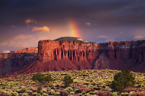
Day 4 - Checking Out Capitol Reef

Today is dedicated to what’s often the least-visited of the Mighty 5, but don’t let that fool you. Capitol Reef delivers adventure both on and off the road.
Layered cliffs, hidden canyons, and quiet stretches of desert reward anyone willing to slow down.
If you’ve got a 4WD, there’s even more to explore. But to keep things simple, we’ll stick to highlights that are accessible to all vehicles.
We’ll start by driving State Route 24, explore Capitol Reef’s biggest attractions, then continue east toward Moab.
Be sure to head out early. Parking is limited at trailheads.
1. Torrey
 Red Rock DmirtyPichugan
It’s a good idea to make sure you’ve got all the supplies you need for the tour before you leave town.
Torrey has the last gas station you’ll see until you reach Hanksville. There are also several picnic opportunities inside the park so now’s the time to stock up on food and water.
If you’re hungry now, grab a delicious breakfast at Capitol Reef Inn & Cafe or a coffee at Dark Sky Coffee before hitting the road.
2. Chimney Rock
Chimney Rock is the first rock formation on the tour as well as the first hiking opportunity.
Chimney Rock Loop Trail is a strenuous 3.6-mile hike that climbs 590 feet in elevation.
But at the top, you’re rewarded with a stunning panoramic view from atop the Mummy Cliffs. There’s no need to wear yourself out right away, though.
There will be plenty of hiking opportunities throughout the day. Consider coming back and doing this one later as the views get even better at sunset.
3. Panorama Point
 Panorama Point, Capitol Reef - Aurore Kerveorn From Getty Images Signature
If you don’t plan on doing any serious hiking today, don’t fret! There are several great viewpoints that don’t require miles of walking to enjoy. Panorama Point offers a great view just a few feet from your car.
4. Goosenecks Overlook & Sunset Point
The views just don’t stop coming! A short and easy 600-foot walk from your car will take you to Goosenecks Overlook with views over Sulphur Creek and beyond.
Just try to imagine a time when the creek was at the same elevation as you before it eroded the rock and dug down some 600 feet to where it is today.
Once you’ve soaked in that view, there’s a second vantage point just a little further away called Sunset Point.
As the name might suggest, the views here at sunset are simply incredible.
5. Capitol Reef National Park Visitor Center
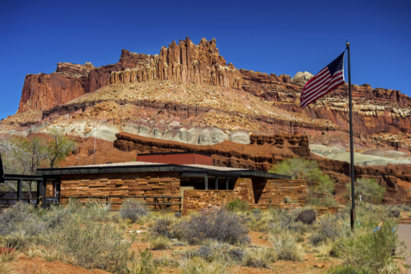 Capitol Reef National Park Visitor Center - AutumnSkyPhotography From Getty Images
You’ll pass two more named rock formations on the way to the Visitor Center.
Feel free to stop in the turnouts near each for photos or drive directly to the Visitor Center.
Here you can view the exhibits and watch a brief film about the park. Don’t miss this opportunity to speak with a park ranger.
Ask about any ranger-led activities for the day like a geology lesson or night sky presentation.
6. Ripple Rock Nature Center & Fruita Orchards
As you leave the Visitor Center, you’ll find yourself driving through the historic Fruita Orchards.
Planted well over 100 years ago by Mormon settlers, the orchards are still producing fruit that you can pick and eat today!
Please be sure to follow the orchard rules and regulations. An easy place to park to enjoy the orchards is the Ripple Rock Nature Center.
If you have kids and you’re visiting during the summer, the Nature Center has programs and activities your children are sure to enjoy.
7. Gifford Home and Museum
The Gifford home offers exhibits detailing what life was like in historic Fruita. They also serve up some fresh pies, made from fruit harvested in the Fruita orchards.
8. The Scenic Drive
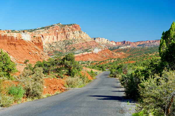 The Scenic Drive - Tristianbnz Getty Images
The Scenic Drive is a 7.9-mile road showcasing fantastic sights. There are also two unpaved spur roads that branch off into canyons.
Don’t worry, normal passenger cars will do just fine—unless the park has closed the roads due to weather.
Flash floods are a real danger. If you see storm clouds, think twice before entering any canyons.
Be mindful of the speed limit and take your time on these roads. Entry to the Scenic Drive costs $20 per car.
9. Grand Wash Spur Road
The spur roads at Capitol Reef offer the chance to see some spectacular geology by car and on foot.
Grand Wash spur road ends at the trailhead for the Grand Wash trail and Cassidy Arch trail.
Grand Wash is an easy hike over flat ground that passes through narrow canyon walls.
Cassidy Arch is a strenuous hike that rises over 400 feet up to the top of Cassidy Arch, named for Butch Cassidy himself.
A turnout along the road also offers a view of Cassidy Arch.
There are additional stops at abandoned uranium mines and Echo Cliff, where, you guessed it, you can hear your echo!
10. Capitol Gorge Spur Road
The Scenic Drive ends at the entrance to Capitol Gorge. This is a much longer and winding spur road than Grand Wash.
Once again, there will be hiking opportunities at the end, and I highly recommend you take the Capitol Gorge trail, at least a little ways in.
A 5-10 minute walk will take you to ancient petroglyphs left by the Fremont culture, who lived in the area hundreds of years ago.
Another 10-15 minutes further, and you can see the Pioneer Register where pioneers and settlers carved their names into the rocks.
From there, you can continue to The Tanks - large divots in the sandstone that collect water and create micro-ecosystems.
You can also hike to a viewpoint of Golden Throne, an impressive mountain peak just north of the gorge.
11. Fruita Schoolhouse
 Historic Fruita Schoolhouse- Sprokop from Getty image
A visit to Fruita isn’t complete without a stop at the Fruita schoolhouse. Peek inside while looking back in time to when a 12-year-old girl was the first and only school teacher in the village!
12. Fremont Petroglyphs
Right down the road from the schoolhouse are more petroglyphs. These are in much better shape than the ones in Capitol Gorge.
Walk the two short wooden walkways to see the images etched into stone.
You can see human figures, animals, and geometric patterns. What kinds of animals can you make out?
13. Capitol Dome and Hickman Bridge
 Capitol Dome and Hickman Bridge - JeffGoulden from Getty images signature
These stops are really piling up on top of each other, aren’t they? Pull into a small parking lot here for views of the Capitol Dome, where half of the name Capitol Reef comes from.
The other half, the “reef,” comes from the raised portion of the waterpocket fold, which reminded early pioneers of impassable reefs in the ocean.
From this parking lot, you can also take several hikes, including Rim Overlook, Navajo Knobs, and Hickman Bridge, which gives you views of two more natural arches.
14. Behunin Cabin
The Behunin cabin is a small sandstone structure that once housed a family of 15.
Most of the children had to sleep outside - the girls in the wagon and the boys in a sandstone alcove behind the cabin. Talk about roughing it!
15. Eastern Viewpoint of the Waterpocket Fold
 Portgrimes from Getty images
From atop a hill near some primitive camping sites, this is a terrific view of the Waterpocket Fold from the east.
From here, you can really see the steep angle at which the land rises. At times, the rock layers are nearly 45 degrees to the horizon.
This is a must-see view as we head east and leave the Waterpocket Fold behind.
16. Notom
 Robert_Ford Getty images signature
This is an optional stop, but recommended if you have time. There isn’t all that much left to see on the way to Hanksville, but we’ve got plenty of fascinating stories to share if you’re interested.
The town of Notom, now not much more than a ghost town, used to be a thriving community much like Fruita.
Here, you can visit a rather curious and unique historical marker as well as the grave of yet another of the Behunin children.
FUN FACT! Legend has it that the town of Notom got its name because, when they were thinking up names for the town, there were “no Toms” living there.
17. Mesa Farm Market
If you didn’t have a picnic lunch at the park, you might be pretty hungry by this point!
If you started your tour at 8:00 am and you’re here on the right day, consider stopping for a bite to eat at Mesa Farm Market. It’s local and organic!
18. Factory Butte
Factory Butte stands solitary and beautiful. Don’t miss this awesome viewpoint!
If you’re feeling adventurous and you’re driving an appropriate vehicle, consider driving a little further north for Moonscape Overlook.
But, a word of warning: plan ahead if leaving the recommended route as many of the roads in the area, even inside the park, require high clearance 4-wheel-drive vehicles.
19. Hanksville
You’ve done it, congratulations! You’ve made it to Hanksville and the end of the tour. But there’s still more to see!
Many prospectors staked claims for gold, silver, copper, and more in this area. Few were as ambitious as Ewin T. Wolverton, who built his mill in 1921.
The Wolverton Mill, located just a half-mile from Route 24, is unique in the area both for its design and its multifunction as a lumber mill and gold ore processor.
Hanksville is a great place to fill up on food and gas before starting your next adventure.
Also, be sure to check out the Rockin’ Riddle Rock Shop and Carl’s Critter Garden before leaving town.

Day 5 - Admiring Arches National Park

Today is all about Arches National Park…hey, you did remember to get your timed entry permit, right? Because you’ll need that even to get into the park. Book yours in advance at recreation.gov.
Couldn’t get a reservation? Then “wakey, wakey,” early riser. You’ll need to be in line by 6:30 A.M. to guarantee a spot…hit the gate after 7:00 A.M., and you’re waiting until 4 P.M. to get in.
Shaka Guide’s Arches tour comes in two flavors: classic and reverse. This itinerary will follow the Classic Arches tour, where we hit most of the stops on the way in.
That does mean that Delicate Arch and Devil’s Garden will be among our last stops, and with such popular hikes, those parking lots fill up quickly.
If you’d rather follow the Reverse Arches tour and head to those parking lots first, that’s totally okay. Your itinerary here will just be more or less reversed.
1. Visitor Center
 PaaschPhotography from Getty Images
The Visitor Center has necessities like water, snacks, and restrooms. This is a good place to fill up your water and purchase a few snacks.
There is no other place in the park that sells food, and the only other place that has drinking water is all the way at the end of the road at Devil's Garden.
2. The Moab Fault
At the Moab Fault viewpoint, you can see the result of enormous pressure that separated the area of the viewpoint from the cliff wall on the other side of the canyon.
3. Park Avenue
City folks say you get the same feeling standing among the rock formations in Park Avenue that you do standing next to the towering skyscrapers in New York city.
4. La Sal Mountains Viewpoint
 Arches National Park from Moab, Utah, Public domain, via Wikimedia Commons
La Sal means the salt in Spanish. The mountains got their name in 1776 when Spanish explorers thought the snowy peaks looked like giant piles of salt.
The highest peak, Mount Peale, is over 12,000 feet and around 3,600 meters high
5. Courthouse Towers
 Courthouse Towers - Bernie ClapCott from Getty Images
Here you’ll find a series of huge sandstone rock formations like the Three Gossips, The Organ, and Sheep Rock.
6. Petrified Dunes
This is a vast landscape of these sorts of lumpy rock formations. It may not look like it at first, but they are sand dunes, like on the Sahara.
More specifically, though, these are petrified sand dunes, meaning that the sand solidified into rock around 200 million years ago.
7. Balanced Rock
 Thomas Wolf, www.foto-tw.de, CC BY-SA 3.0, via Wikimedia Commons
Balanced Rock stands over 120 feet or 11 stories tall. This giant Hoodoo has a ball on top that appears to be perfectly balanced on the spire below.
8. The Windows & Double Arch
This area features more than 30 different magnificent arches, including The Windows, Turret Arch, and Double Arch, which were featured in the opening scenes of Indiana Jones and the Last Crusade.
9. Garden of Eden
 Garden of Eden by LordRunar from Getty Images Signature
The Garden of Eden is a great place to wander around. This is an open terrain dotted with fins, windows, and miniature arches, or even arches still being formed.
There's no designated trail, so be sure you watch your step for any biocrust. You can find the owl rock just a short distance from the parking lot.
9. Pothole Arch
The Pothole Arch is unlike the rest of the arches you’ll see on the tour because, while those arches are vertical, this arch is horizontal.
10. Panorama Point
From this high vantage point, you can see for miles and miles in several directions.
To the north is Devil's Garden and the Fiery Furnace.
To the south, you can see Elephant Butte, the highest point in the park at 5,600 feet.
11. Delicate Arch Trail
 Pedro Lastra peterlaster, CC0, via Wikimedia Commons
This is probably the most famous Arch in Arches National Park. In fact, it’s on the Utah state license plate!
While Delicate Arch is certainly not one of the tallest in the park, this iconic formation has a special charm that has attracted people from all over the world.
12. Delicate Arch Viewpoints
If you don’t have time or don’t have a reservation to make the three-mile hike to Delicate Arch, you can still see the arch from two viewpoints.
The trail to the lower viewpoint is just a short 100-foot walk from the parking lot. The second trail is about a half-mile round trip to the upper viewpoint.
13. Salt Valley Overlook
The Salt Valley was once called the paradox formation because early geologists couldn’t determine how it was created.
It’s a good thing you’ve got Shaka Guide to make everything clear.
14. Fiery Furnace
 Murray Foubister, CC BY-SA 2.0, via Wikimedia Commons
This place got its name because the rocks here glow as if they're on fire when the sun is at the right angle.
There is a permit-only hike through the Fiery Furnace, but permits are limited and must be reserved online.
We don’t recommend the hike on our tour due to its difficulty, but if you want to hike it, you can make a reservation for Fiery Furnace here.
15. Sand Dune Arch, Broken Arch, & Tower Arch
Here, you can walk a short distance to visit Sand Dune Arch, which includes a sort of sand pit that children of all ages like to play in.
There’s a two-mile hike to Broken Arch and a rough road that will take you further to Tower Arch.
16. Skyline Arch
 Arches National Park, Public domain, via Wikimedia Commons
This large arch sits just above the horizon, framing the sky as a wonderful window arch.
No hiking is required, but if you want, just 10 minutes on foot will get you up close to the arch.
17. Devils Garden
At Devil's Garden, miles of trail systems connect seven arches and numerous fins, spires, and other formations.
We recommend you set aside some time to park here, walk around, and check out the arches.
The hike is short - about two miles - and it's well worth it. You'll also find picnic tables and a restroom if you want to relax for a while.
The most famous formation at the Devil's Garden Trail is the Landscape Arch, the longest arch in North America.
Day 6 - Cruising through Canyonlands

No long drives today, because we’re just setting off from Moab. So, you could, technically, start your day a little later.
However, trails like Mesa Arch fill up early–we’re talking sunrise early. That means if you’re hoping to do some of the big-name hikes, it’s still worth getting to the park as early as you can. Or, just plan on hiking in the afternoon–parking lots start to clear out after 2 p.m.
Just be aware of the high temperatures for the day–you don’t want to try and fight that afternoon heat.
1. Intestine Man Art Site
Approximate Time: 10 minutes
The first stop on the tour is the Intestine Man Art Site. This site features ancient petroglyphs and pictographs created by at least three different groups of indigenous peoples:
- the Ute
- Southern Paiute, and
- Pueblo
Follow the short trails on the right side of the road to the cliffside to find the ancient art.
2. Monitor & Merrimac Viewpoint
 by (c)Sean Board from Getty Images
Approximate Time: 2 minutes
The two buttes you can see from this viewpoint, the Monitor and the Merrimac, were named for their resemblance to the first American-made ironclad warships.
Built during the Civil War, these ships helped usher in the modern era of Naval warfare.
3. Navajo Rocks Mountain Biking Trail
Approximate Time: 1 minute
Mountain biking is a popular activity in Canyonlands and the surrounding area.
The Navajo Rocks trail is singletrack and varies in difficulty from flowy to technical.
You’ll keep driving while we tell you about this spot.
4. Dead Horse Point
 Dead Horse Point by DmitryPichugan from Canva
Approximate Time: 24 minutes
Dead Horse Point State Park lies just off the road to Canyonlands, rests on the same mesa as Island in the Sky, but offers a wholly unique view.
Learn about the history, ancient and modern, of this popular state park and scenic overlook.
4. Island in the Sky Visitor Center
Approximate Time: 2 minutes
The Canyonlands Island in the Sky Visitor Center is the only place in the district to find potable water and flushing toilets.
Stop here to pay your entrance fee, talk to a ranger, and visit the bookstore.
5. Shafer Canyon Overlook & Neck Spring Trail
 by Bartfett from Getty Images
Approximate Time: 2 minutes
From this viewpoint, you can look down on the Shafer Trail as it winds its way down the mountain via a series of narrow switchbacks.
If you’re feeling adventurous and you have the right kind of vehicle, you might consider taking the Shafer Trail back to Moab after the tour.
6. Mesa Arch
 Torsten Bøgh Köster, CC BY 3.0, via Wikimedia Commons
Approximate Time: 9 minutes
The trail to Mesa Arch is an easy half-mile round trip over dirt and slickrock.
The views at Mesa Arch and the arch itself are fantastic at sunrise.
And this is a sentiment shared by many because the parking lot begins to fill up while it’s still dark outside.
Get started early to make sure you get a spot!
If you can’t find a spot, try stopping by in the afternoon after you complete the tour.
7. Candlestick Tower Overlook
 NPS Natural Resources, Public domain, via Wikimedia Commons
Approximate Time: 2 minutes
The next stop is another iconic formation in the park called the Candlestick Tower.
The name comes from its shape, which resembles a melting candlestick.
This 450-foot tower is a popular rock climbing spot.
If you visit during fall or winter, you might be able to catch a glimpse of a brave soul or two making their way up the tower.
8. Buck Canyon Overlook
Approximate Time: 5 minutes
Buck Canyon Overlook offers an amazing canyon view of the gorgeous geological layers in the Canyonlands and the beautiful mountains in the distance.
9. White Rim Overlook
 SteveLegreca by Getty Images
Approximate Time: 5 minutes
At the White Rim Overlook, you can hike a relatively flat,1.8-mile round-trip trail and see a stunning 360-degree view of the canyon.
But if you're not feeling up to it, there's also an overlook that requires just a short walk from the parking lot.
From this overlook, you can see the handiwork of the Colorado River carving out the landscape.
10. Orange Cliffs Overlook
Approximate Time: 3 minutes
From this overlook, you can see the orange cliff section of Glen Canyon recreational area which borders Canyonlands.
You can also see the maze district, the most remote part of the park.
11. Grand View Point Overlook
 by strokop from Getty Images
Approximate Time: 2 minutes
Looking down from the grand viewpoint, you can see a complex network of canyons carved by the Colorado and Green rivers.
If you're feeling up for a two-mile round-trip hike, follow the trail to the tip of the island in the sky, mesa. This is one of the best hikes in the entire park.
12. Green River Overlook
 Ron Clausen, CC BY-SA 4.0, via Wikimedia Commons
Approximate Time: 15 minutes
This overlook offers yet another breathtaking view of the canyon over a thousand feet below the road, carved out by the peaceful yet powerful Green River.
The river shaped much of the landscape in this part of the country, originating from Wyoming on the left side of the continental divide.
13. Aztec Butte Trail
Approximate Time: 5 minutes
Aztec Butte Trail is a 1.7-mile round-trip hike that leads to some ancestral Puebloan stone granary structures with some amazing views.
The granary was built roughly 800 years ago, around 1200 AD.
14. Whale Rock
Approximate Time: 7 minutes
The name Whale Rock comes from the rock’s resemblance to a blue whale.
It does take a little imagination for you to see it, though.
There is a one-mile round-trip hike up to the giant rock with great views on top that’s rated as easy to moderate.
15. Upheaval Dome
 Phil Whitehouse from London, United Kingdom, CC BY 2.0, via Wikimedia Commons
Approximate Time: 2 minutes
Known by several nicknames, including Utah’s Belly Button, this structure is the biggest mystery of Canyonlands because scientists can’t agree on how it was formed.
There are two ways to explore the dome. The first is to follow a one-mile round-trip trail to the overlooks (our recommendation).
The second is to hike an eight-mile trail that wraps around the Ridge of the crater.
It's not only challenging, but it's also where most of the rescues in the park happen.
16. Alcove Spring Trail
Approximate Time: 2 minutes
This is a rough 12-mile round-trip hike with a steep descent into the canyon.
There, you’ll find two 500-foot rock towers named Moses and Zeus.
Day 7 - Heading Home
Other Options
Today, we have a few different options, depending on what your plans are. If you’re leaving Utah today, it might be time to head back to your airport or hotel in Las Vegas, St. George, or Grand Junction.
Moab → Las Vegas: ~7–7.5 hours (about 460 miles)
Moab → St. George: ~5–5.5 hours (about 300 miles)
Moab → Grand Junction: ~1 hour 45 minutes to 2 hours (about 113 miles)
However, if you have an extra day or several, you could add another day or two of adventure. Some ideas are:
- heading back towards Kanab or
- Kolob Terrace in Zion,
...or continuing on to
- South Rim of the Grand Canyon
- North Rim of the Grand Canyon
- Mesa Verde, or
- Black Canyon of the Gunnison
Oh, and you don’t need to worry about stopping and looking everything up. We’ve got tours ready to guide you through it all!
Entry Fees, Reservations & Hiking Permits
 Shutterstock Image
All Utah national parks charge entrance fees, or you can use an America the Beautiful Pass if you’re visiting multiple parks.
Some parks—most notably Zion and Arches—require timed entry or shuttle reservations during peak season.
In addition, certain hikes require permits, including Angels Landing in Zion and Fiery Furnace in Arches. Make your reservations at recreation.gov.
What should I pack for a Utah road trip?
Pack layers—Utah’s desert mornings and mountain evenings can be cold, even in summer. Bring sturdy hiking shoes, sun protection, plenty of water, and snacks since services are limited inside the parks. A cooler helps on long drive days. Because cell service can be unreliable, download maps, reservations, and your Shaka Guide tours ahead of time.
What is the Best Time to Visit the Mighty 5?
Late spring (April–May) and fall (September–October) are the best times to visit Utah’s Mighty 5. Temperatures are comfortable, most trails are open, and crowds are lighter than peak summer.
Summer brings extreme heat and heavy visitation in parks like Zion National Park and Arches National Park, while winter is quiet and scenic but limits access at higher elevations such as Bryce Canyon National Park.
Where should I stay along a Mighty 5 road trip route?
Plan lodging around park clusters to reduce long drives. Stay in Hurricane or Springdale for Zion National Park. For Bryce Canyon National Park, choose Bryce Canyon City or Tropic.
Torrey is the best base for Capitol Reef National Park. Moab covers both Arches National Park and Canyonlands National Park, offering the widest range of lodging, food, and activities. Book early—these towns fill fast in peak season.
Frequently Asked Questions
Can you really visit all five Utah national parks in one week?
Yes. One week is enough to see the highlights of all five parks if you plan efficiently and accept that you won’t see everything. That’s normal—and part of the appeal.
Do I need a 4WD vehicle for the Mighty 5 itinerary?
No. All major park roads and highlights are accessible with a standard vehicle. A 4WD only adds optional backcountry routes.
How much driving should I expect on a Utah Mighty 5 road trip?
Plan for 2–5 hours of driving on transition days. Early starts make everything easier. It’s best to drive to your next hub in the evening, so you can have an early start the next morning.
Is the Mighty 5 itinerary family-friendly?
Yes. Each park offers viewpoints and short walks, with optional longer hikes for older kids or adults. Plan for heat, limited bathrooms, and snacks.
Which Utah national parks are dog-friendly?
Short answer: mostly none—at least when it comes to trails. Dogs are allowed in developed areas, campgrounds, and along paved roads, but not on most hiking trails.
- Zion: Dogs allowed on the Pa’rus Trail only (leashed).
- Bryce Canyon: Dogs allowed on paved areas and a short section of Rim Trail between Sunset and Sunrise Points.
- Arches, Canyonlands, Capitol Reef: Dogs allowed in campgrounds and along paved roads, not on trails.
Leashes are required everywhere, and heat is a serious concern. If you’re traveling with a dog, plan walks carefully—or look to nearby BLM land for more flexibility.
Explore with Shaka Guide
Want directions, stories, and timing handled for you? Shaka Guide’s Utah audio tours play automatically as you drive through each park, sharing geology, history, and hiking tips right when you need them. No cell service required. Just download the tours, hit play, and let Utah unravel all from your dashboard.

Rachel Ennis is a storyteller, nature nerd, and park enthusiast who believes every trail has a tale. Before venturing to the far corners of Utah, she knew the sweeping red vistas of the Navajo Nation would steal her heart—but what truly surprised her was how deeply they stayed with her.
It’s more than just the views; it’s the vast silence and open space, rich with histories patiently waiting to be shared. Today, she’s continuing on her mission to share the stories that live in the land and the spaces that make us feel small in the best way.
Like this article? Share it on Pinterest!
RELATED ARTICLES