


Hiking Devil's Bridge in Sedona: Everything You Need To Know

- No permit needed to hike Devil’s Bridge, but you must display a Red Rock Pass while parking.
- Using a 4WD high-clearance vehicle from Devil’s Bridge Trailhead cuts the hike to about 2 miles round trip.
- Without 4WD, park at Dry Creek Vista or Mescal trailheads and expect a 3- to 4.6-mile hike.
- Aim to start before 7 a.m. to beat crowds, secure parking, and avoid midday heat.
- Bring plenty of water, sun protection, and wear closed-toe shoes; the final ascent involves rock steps.
TABLE OF CONTENTS
- How to Get to Devil's Bridge in Sedona
- Does Sedona have a Shuttle service?
- What time of day is best for Devils Bridge?
- What Should I Pack to Hike Devil's Bridge?
- Sedona Hiking Trails
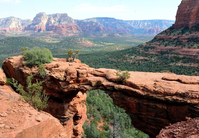
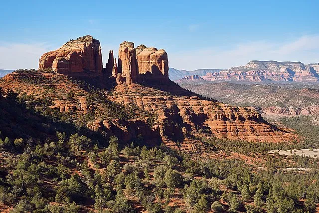
Devil’s Bridge is one of Sedona’s most popular hiking spots. This natural bridge is only a few miles away from the center of town and is a doable hike for most people.
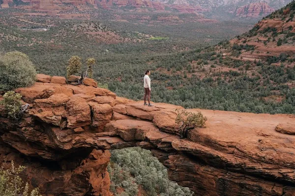
After hiking through desert scrub, prepare to wait in line at the bridge as everyone takes their time getting their perfect, Instagrammable shot. So, what’s the scoop on this hike?
About Devil's Bridge
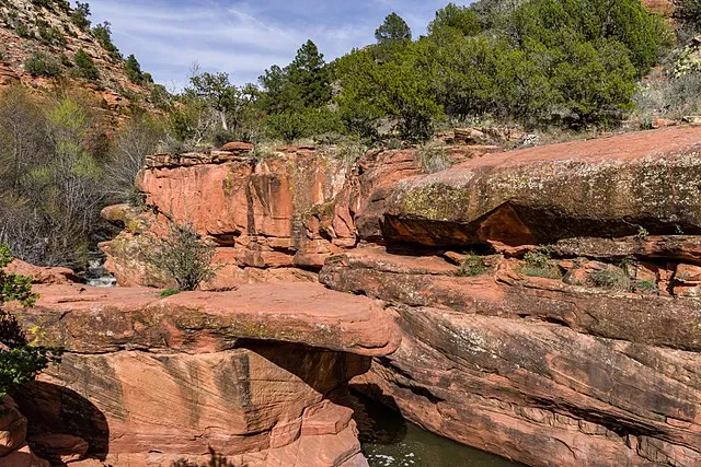
Devil’s Bridge is a little over three miles northwest of Old Town Sedona. This beautiful sandstone arch got its bridge shape after wind and water eroded the rock underneath.
There are no reservations or permits needed to visit, so you’re free to hike at your leisure.
But, the trail time and difficulty are not so straightforward, because there are multiple ways you can approach the popular rock formation.
Depending on which trailhead you use, you should expect to spend one to three hours hiking.
Though you don’t need a reservation to hike at Devil’s Bridge, you will need to purchase a Red Rock Pass to park your car at any of the trailheads.
There are kiosks to purchase a pass at the trailhead parking lots, or you can purchase one in Sedona in many locations, including the visitor center.
Red Rock Passes to choose from:
- Red Rock Pass (1 Day) - $5
- Red Rock Pass (7 Days) - $15
- Red Rock Annual Pass - $20
Or, if you happen to have an America the Beautiful pass from the National Park Service, you can display the pass on your dashboard, and you’re all set.
America the Beautiful Passes:
- Annual Pass - $80
- Military Annual Pass - Free
- Military Lifetime Pass - Free
- 4th Grade Pass - Free (Sept - Aug)
- Senior Pass (Lifetime) - $80
- Senior Pass (Annual) - $20
- Access Pass (with disabilities) - Free
RELATED: The Ultimate Sedona Travel Guide
How to Get to Devil's Bridge in Sedona
Because of the multiple access points and relative difficulty in finding parking, Devil’s Bridge is not on the Shaka Guide driving tour.
Which trailhead you use to access Devil’s Bridge determines the length and difficulty of the walk.
But not every starting point is accessible with an ordinary car. So let’s break it down, starting with the closest.
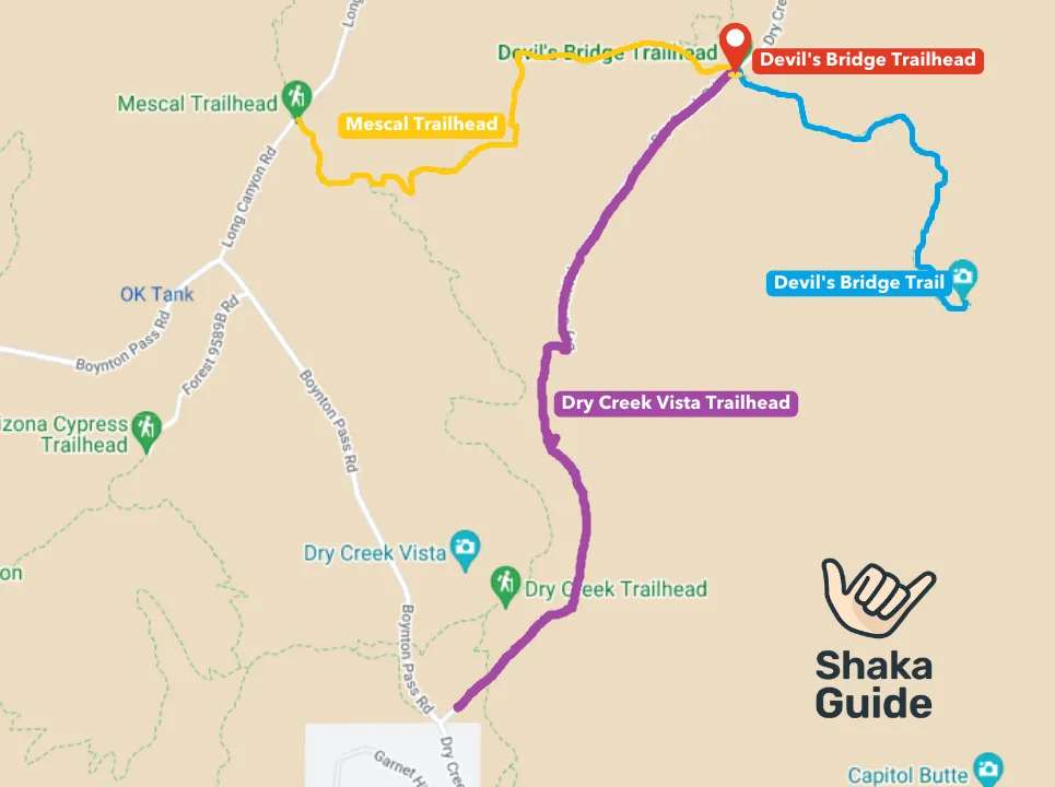
1. Devil's Bridge Trailhead
The closest starting point is obviously the Devil’s Bridge Trailhead. From here, the hike is about 2 miles round-trip and takes about 1.5 to 2 hours.
The trail remains relatively flat until the stairs up to Devil’s Bridge itself. But, there’s a major caveat here.
In order to reach the trailhead by car, you will need a high-clearance, four-wheel drive (4WD) vehicle to drive about 1.3 miles on a very rocky road.
It’s possible to rent a Jeep in Sedona for just these sorts of excursions.
Devils Bridge Trailhead to Devils Bridge Hiking:
- Hike Distance: 2 miles
- Time Required: 1.5 to 2 hours
- Elevation: 400 feet
- Difficulty: Moderate

2. Dry Creek Vista Trailhead
If you don’t have a 4WD vehicle, your next option is to park at the Dry Creek Vista Trailhead.
After parking in the paved lot, you’d hike up the 1.3-mile road that the 4WD cars are able to take.
This turns the 2-mile hike into a 4.6-mile or even longer if the parking lot fills up and you park along the side of the road.
And you’re looking at about a 3-hour hike. The hike along the road isn’t necessarily scenic, so this is not the ideal starting point.
Dry Creek Vista Trailhead to Devils Bridge Hiking:
- Hike Distance: 4.6 miles
- Time Required: 3 hours
- Elevation: around 450 feet
- Difficulty: Moderate
3. Mescal Trailhead
A better option is to start at the Mescal Trailhead. Starting here makes for a slightly shorter hike, at a little over 4 miles and roughly 3 hours round trip.
And it’s a much more enjoyable hike than the walk up a dirt road. The trail remains mostly flat all the way to the bridge.
Just keep an eye out for mountain bikers, who also use the trail. The one issue here is that the parking lot is relatively small, so there’s no guarantee that you’ll find a spot.
RELATED: Driving to Sedona from Phoenix
Mescal Trailhead to Devils Bridge Hiking:
- Hike Distance: 4 miles
- Time Required: 3 hours
- Elevation: around 500 feet
- Difficulty: Easy to Moderate
Does Sedona have a Shuttle service?

Now, if you don’t feel like driving out there and dealing with parking, you can always see if the Sedona Shuttle is running during your visit.
This free service takes you from central Sedona to a number of the area’s most popular trailheads, including the Dry Creek Vista and Mescal Trailhead lots.
Things to know about the Sedona Shuttle:
- The shuttle runs from Thursday through Sunday from 7:00 AM to 5:30 PM
- Shuttles can accommodate up to two wheelchairs.
- Can accommodate 20 seated passengers
- Each shuttle bus is equipped with a bike rack
- Restrooms and trash cans are available at the pick-up and drop-off areas
RELATED: 15 Things to Do in Sedona
What time of day is best for Devils Bridge?
Like almost anywhere in Sedona, Devil’s Bridge is a very popular hiking spot. The middle of the day, with day trippers from Phoenix or elsewhere, is the busiest, so you’ll want to avoid coming between 10 am and 3 pm.
This strategy also allows you to try to catch a sunrise or sunset, and to avoid the hottest part of the day.
The twilight hits those red rocks just right! But even in these off-hours, you’re still likely to find a lot of people around.
If you’re coming specifically for sunrise, you’ll want to arrive no later than 7 am.
What Should I Pack to Hike Devil's Bridge?
This being the desert, you’ll want to make sure you pack plenty of water for everybody who’s hiking. Bring good, closed-toed hiking shoes and a hat or sunscreen to protect yourself from the sun. And don’t forget your camera!
Must remain in the action? Sedona Uptown Suites' eight rooms are a value for the Uptown neighborhood and conveniently close to a ton of eateries, pubs, and stores.
Other Sedona Hiking Trails
Fay Canyon Trail
 Coconino National Forest, CC0, via Wikimedia Commons
- Distance from Uptown Sedona: 8 miles
- Length: 2.3 miles
- Completion time: 1 hour
One of Sedona’s easier and more popular hikes, the Fay Canyon Trail sticks to the canyon floor and takes hikers past canyon walls and spectacular rock formations.
And this trail has what few other Sedona trails have: shade!
Trail spurs leading to a rock arch and a viewpoint beyond the trail’s end require some scrambling and make the hike moderately difficult.
RELATED: Airport for Sedona, AZ
Bell Rock Trail
 Coconino National Forest, CC0, via Wikimedia Commons
- Distance from Uptown Sedona: 5.5 miles
- Length: 0.8 miles
- Completion time: 30 minutes
It’s easy to approach Bell Rock, with a wide, flat pathway going straight to the iconic butte that looks a little like Disney World’s Space Mountain.
How far up you want to go after that, and how difficult you want this hike to be, is up to you.
But, it’s totally worth it to scramble up a bit and get a nice view of Courthouse Butte right next door, as well as Cathedral Rock and the city of Sedona itself, not too far off.
RELATED: Sedona in December
Cathedral Rock Trail
 Nikolai Gates Vetr, CC BY-SA 4.0, via Wikimedia Commons
- Distance from Uptown Sedona: 4.5 miles
- Length: 1.2 miles
- Completion time: 1-2 hours
Perhaps the most popular hiking trail in Sedona (good luck getting a parking spot!), the Cathedral Rock Trail goes up over 700 feet in about a half mile.
Make sure to bring appropriate shoes–some parts of the trail are a scramble with some mild climbing.
The reward in the saddle of the butte is a breathtaking view of the surrounding red rock scenery, and the butte itself. If you’re up to it, consider this a sunrise or sunset hike.
Of course, these aren’t the only fantastic trails in Sedona. In fact, there are over 400 miles of trails in the area. Check out our list of 14 Amazing Hikes in Sedona for our favorites!
Like this article? Share it on Pinterest!

Visiting Sedona? Check out our Sedona Driving Tour!
RELATED ARTICLES:
The Ultimate Sedona, Arizona Travel Guide
Know Before You Go: Shaka Guide's Sedona Tour
Driving to Sedona from Phoenix
Driving Between the Grand Canyon and Sedona, Arizona

Matt Caracciolo is a travel writer based in Ohio and author of the Shaka Guide tour for Yosemite. Born and raised in Columbus, Matt fell into travel writing while teaching English abroad in South Korea.
He has written two travel books, including the Moon Ohio guidebook, and enjoys writing and editing tours for Shaka Guide. Matt follows Mark Twain’s belief that “travel is fatal,” embracing travel as a way to learn more about the world and ourselves.


 to fuel your ride
