


Stops and things to do from Phoenix to Sedona Drive

The Phoenix to Sedona drive is truly an epic road trip. A two-hour drive through a drastically changing desert landscape, Sedona is a perfect day or weekend trip from Phoenix and easily doable on any budget.
- The drive from Phoenix to Sedona is approximately 117 miles, taking about two hours via I-17.
- Notable stops along the route include Sunset Point Rest Stop, Agua Fria National Monument, and Montezuma Castle National Monument.
- Alternative routes through Camp Verde and Cottonwood offer additional attractions like Out of Africa Wildlife Park and historic downtown areas.
TABLE OF CONTENTS
- How Long is the Trip From Phoenix to Sedona?
- What is the Drive from Phoenix to Sedona Like?
- Stops on the Phoenix to Sedona Drive
- What is There to Do In Sedona?
- Should you Drive from Phoenix to Sedona?
How Long is the Trip From Phoenix to Sedona?
 DPPed, CC BY-SA 3.0, via Wikimedia Commons
The journey from Phoenix to Sedona is not very long. With normal traffic, it takes about two hours to travel the 117 miles between Downtown Phoenix and the center of Sedona.
It’s about the same distance and travel time from Phoenix Sky Harbor International Airport, which is where most people fly into when they visit Arizona.
Direct Route

The most direct route to Sedona is taking I-17, a wide, well-maintained interstate highway, all the way to AZ-179. AZ-179 becomes the Red Rock Scenic Byway as it snakes north into Sedona. This is the most beautiful way to enter Sedona, but everyone knows this.
Therefore, traffic can really back up for miles as people from Phoenix try to sneak into town for a day or weekend trip. Going this way may add another 30 minutes to an hour of drive time, so if you want to come this way, plan to leave early to avoid traffic.
Alternative Route

One alternative is to take I-17 north but exit at AZ-260 by the city of Camp Verde. From here, you’ll take AZ-260 north through the pleasant city of Cottonwood and then head north on AZ-89A toward Sedona.
This detour only takes a few minutes longer, but you’ll enter Sedona through the back door, so to speak, side-skirting the long line of traffic getting into town.
RELATED: The Best Airport for Sedona, AZ: Flying to Sedona
What is the Drive from Phoenix to Sedona Like?
 Terry Donaghe from Scottsdale, AZ, USA, CC BY-SA 2.0, via Wikimedia Commons
Driving on the large interstate highway I-17, it takes some time to escape Phoenix’s suburban sprawl, but eventually, the neighborhoods and retail developments give way to a Saguaro-filled desert. But, as I-17 heads north, it’s almost continuously gaining in elevation all the way to Flagstaff.
To give you an idea, Phoenix’s average elevation is about 1,000 feet above sea level. Compare that to Sedona’s, which is 4,350 feet above sea level.
This means that you’ll say goodbye to the low-lying Saguaro cacti pretty quickly, and the landscape shifts to desert plains and mountains. And of course, the temperatures cool as the elevation increases, which is a plus.
If you continue to Flagstaff in winter, you might be shocked to start your drive with cacti and end it with snowy pine forests! But, in Sedona, you’re unlikely to find much snow, though a magical dusting over the red rocks is a possibility in the winter months.
RELATED: The Ultimate Sedona, AZ Travel Guide

Unique Stops on the Phoenix to Sedona Drive, AZ
 Sunset Point Rest Stop / Roller Coaster Philosophy, CC BY 2.0, via Wikimedia Commons
The drive between Phoenix and Sedona is, for the most part, empty but beautiful desert mountains. But that doesn’t mean there aren’t some interesting stops along the way.
Sunset Point
Halfway through the trip, about an hour north of downtown Phoenix, is a rest stop called Sunset Point. While you may not need a rest stop on such a short drive, it’s worth hopping off the road for a few minutes for the magnificent view. Plus, it never hurts to use the restroom.
RELATED: How to Hike Devil's Bridge in Sedona, Arizona
Agua Fria National Monument
 Image from Flickr by Bureau of Land Management (BLM) Arizona
Just north of Sunset Point is Agua Fria National Monument. There’s not much in the way of services or infrastructure here, but if you’re enjoying the high desert landscape and want to stretch your legs, you can hop off the highway on Exit 256 for Badger Springs Road.
Drive about a mile on a gravel road to the Badger Springs Trailhead. This is an easy, 1.5-mile out-and-back trail to a green oasis along the creek. And you’ll be treated to some petroglyphs too!
RELATED: Driving Between the Grand Canyon and Sedona, Arizona
Montezuma Castle National Monument
 Image from Flickr by kinglear55
If you decide to take the alternate route to Sedona by exiting the city of Camp Verde, then you set yourself up for some good side excursions. The best one is Montezuma Castle National Monument. This architectural gem on the side of a cliff was built by the Sinagua people nearly 1,000 years ago.
Out of Africa Wildlife Park
Another option near the Camp Verde exit is the Out of Africa Wildlife Park. Ride in a safari vehicle as your guide drives you through pens of free-ranging exotic animals such as giraffes, zebras, and antelope. The more zoo-like section features spacious exhibits and popular zoo animals such as lions, tigers, monkeys, and wolves.
Cottonwood
The city of Cottonwood is, generally speaking, a less crowded and less expensive but no less tasty place to find food than Sedona. If you’re coming in this way, consider grabbing a bite to eat in town, especially in the Old Town Cottonwood stretch of Main Street, before heading to Sedona.
RELATED: 14 Amazing Hikes in Sedona
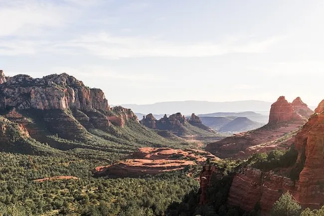
What is There to Do In Sedona?
 Gillfoto, CC BY-SA 4.0, via Wikimedia Commons
Well now that you’ve made it to Sedona, what do you do? You wish you had more time, that’s what you do!
- Explore Sedona’s 200 trails, totaling over 400 miles crisscrossing the desert.
- Rent a 4x4 vehicle and explore the area’s backcountry roads, or take a jeep tour.
- Enjoy a mountain biking trail through red rock country.
- Camp in nearby Coconino National Forest.
- Eat your way through Sedona’s culinary scene, or visit the city’s many shops.
- Golf at any of Sedona’s clubs.
And of course, you can take Shaka Guide’s Sedona, AZ Tour. Our self-guided audio tour takes you to many of the most popular locations surrounding Sedona including Oak Creek Canyon, Red Rock Loop Road, and Red Rock Scenic Byway. The tour is customizable, allowing you to prioritize or skip stops based on time and interest.
RELATED: 15 Things to Do in Sedona
Should you Drive from Phoenix to Sedona?
Absolutely! Driving from Phoenix to Sedona is a breeze and a beautiful one at that. Let Shaka Guide be your front-seat passenger as we share what Sedona has to offer.

Like this article? Share it on Pinterest!

Ready to explore Sedona?
Take Shaka Guide’s Sedona, Arizona Audio Tour for turn-by-turn directions, local stories, and the freedom to explore at your own pace.
Visiting more parks in the region?
Don’t miss our Arizona Tour Bundle — it includes tours for Grand Canyon, Tucson, Horseshoe Bend, and many more!
Still planning?
Check out our Sedona Itinerary and Know Before You Go guide to prep for your trip.
Have questions?
We’re happy to help — email us at aloha@shakaguide.com.
RELATED ARTICLES ABOUT SEDONA:
The Ultimate Sedona, Arizona Travel Guide
How to Hike Devil's Bridge in Sedona, Arizona
Driving Between the Grand Canyon and Sedona, Arizona
Know Before You Go: Shaka Guide's Sedona Tour

Matt Caracciolo is a travel writer based in Ohio and author of the Shaka Guide tour for Yosemite. Born and raised in Columbus, Matt fell into travel writing while teaching English abroad in South Korea.
He has written two travel books, including the Moon Ohio guidebook, and enjoys writing and editing tours for Shaka Guide. Matt follows Mark Twain’s belief that “travel is fatal,” embracing travel as a way to learn more about the world and ourselves.


 to fuel your ride
