


Shaka Guide's Scenic Byway 12 Tour Itinerary

Welcome to Shaka Guide’s Scenic ByWay 12 driving tour! We’ve provided a handy itinerary for you so you know what to expect.
Scenic Byway 12 Itinerary
3.5 hours to 8 hours
Considered one of the most scenic drives in the United States, Scenic Byway 12 highlights some of the unique geology of the region.
The drive itself with no stops will take you roughly 2 and a half hours, but we here at Shaka Guide have found some fantastic stops, stories, and side trips to make your trip unforgettable.
COMING FROM ZION NATIONAL PARK:
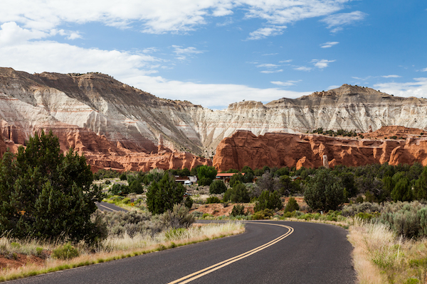
1. Red Canyon State Park
 Frank Kovalchek, CC BY 2.0, via Wikimedia Commons
Approximate Time: 1 hour-3 hour
The Red Canyon hikes are some of the most scenic and breathtaking in the country.
Whether you’re looking for an easy stroll or a strenuous trek through the red rock hoodoo formations, Red Canyon State Park is a great place to stretch your legs.
It provides a sneak peek of what Southern Utah has to offer.
2. The Red Canyon Arches
 Mobilus In Mobili, CC BY-SA 2.0, via Wikimedia Commons
Approximate Time: 5 min-10 min
Be sure to stop along the pullouts on Scenic Byway 12 to get some up close and personal pics of the natural stone arches that were once called the Gateway to Fairyland!
3. Bryce Canyon City (Route 64)
 Ntsimp, Public domain, via Wikimedia Commons
Approximate Time: 5 min-2 hours
Route 64 through Bryce Canyon City is the main road into Bryce Canyon National Park, and there’s no lack of activities here!
Bryce Canyon City is home to Ruby’s Inn, which has been around since the early 1900s.
Ruby’s isn’t just a hotel, though. Ruby’s consists of several properties:
- a general store
- three restaurants
- an “old town” mini-mall with gift shops
- an ice cream parlor, and
- a working gem mine!
They also offer many unique ways to see the park:
- horseback riding tours
- guided ATV tours
- bike rentals, and
- even helicopter rides
4. Bryce Canyon National Park
 King of Hearts, CC BY-SA 4.0, via Wikimedia Commons
Approximate Time: 2 hr-5 hr
Bryce Canyon National Park is a ca n’t-miss detour along Scenic Byway 12.
From hoodoos to hikes to beautiful night skies, Bryce Canyon has so much to offer that you may want to spend several days exploring it!
Shaka Guide offers an entire Bryce Canyon audio tour to enhance your experience in this lesser-known hidden gem in the National Park crown.
5. Mossy Cave Trail
 Don Graham from Redlands, CA, CC BY-SA 2.0, via Wikimedia Commons
Approximate Time: 1 hour-2 hours
Even though it’s 12 miles away from the entrance gate, Mossy Cave Trail is still technically part of Bryce Canyon National Park.
That means even if you skip Bryce this time around, you can still enjoy one of its most peaceful gems.
The parking area and trailhead to this easy 1-mile hike are right along Scenic Byway 12.
RELATED: Shaka Guide’s Bryce Canyon National Park Itinerary
6. Tropic, Utah
 Howcheng / Byways
Approximate Time: Up to 1 hour
Scenic Byway 12 passes right through Tropic, Utah. Although the town isn’t an official stop on our tour,
Tropic is a tiny town with a big heart and a surprising number of amenities.
There are a variety of:
- gift shops
- outdoor and hardware stores
- restaurants
- gas stations, and
- even an old-fashioned candy store
...so that you can stock up on those all-important road-trip snacks!

7. Kodachrome Basin State Park
 Murray Foubister, CC BY-SA 2.0, via Wikimedia Commons
Approximate Time: 1-3 hour
Kodachrome Basin State Park is the next optional stop on our road trip.
With over 2,000 acres of slot canyons, secret caves, and stone spires not found anywhere else on the planet, this park is one worth seeing!
Kodachrome is open from dawn to dusk, usually about 6 am to 10 pm, and charges a small day-use fee.
8. Powell Point Vista
 Carpenter, Kenneth, CC BY-SA 4.0, via Wikimedia Commons
Approximate Time: 10-15 min
At 10,118 feet above sea level, Powell Point Vista offers stunning, sweeping views.
You can see the Pink Cliffs of the Claron Formation and the blue-green shale known as The Blues, which make up the Kaiparowits Formation.
9. Upper Valley Granaries Viewpoint
 National Archives and Records Administration, Public domain, via Wikimedia Commons
Approximate Time: 10-15 min
In ancient times, the Ancestral Puebloans built camouflaged structures called Granaries to store their food surplus and keep it safe from wildlife.
This viewpoint gives you the opportunity to see just how camouflaged they were!
10. Escalante Petrified Forest State Park
 Mramoeba, CC BY-SA 4.0, via Wikimedia Commons
Approximate Time: 1-3 hours
Take a stroll through ecological history at Escalante Petrified Forest State Park and relax at the edge of the Wide Hollow Reservoir.
The trees here have undergone a million-year transformation to become vibrant-colored petrified wood.
Enjoy scenic hikes, swimming, boating, fishing and so much more!
This park has a small day-use fee (generally between $4 and $8) which goes directly to the preservation and upkeep of the park.
11. Escalante, Utah
 Brian W. Schaller, FAL, via Wikimedia Commons
Approximate Time: 1-2 hours
Welcome to the town named for the river named for the Spanish priest that started it all! Escalante is the perfect pit stop on your Scenic Byway 12 road trip.
Visit the Escalante Interagency Visitor Center and learn more about the unique geology and ecology of the region, and get up-to-date information about road conditions and special events.
12. Hell’s Backbone Scenic Backway
 runt35, CC BY 3.0, via Wikimedia Commons
Approximate Time: 2-3 hours
This is an optional detour along your route, and fair warning; it’s not for the faint of heart.
The Hell’s Backbone Road was originally constructed during the Great Depression as an alternate trade route from Escalante to Boulder, Utah.
When we say “optional detour”, we mean that this is more of an “alternate route”.
Hell’s Backbone is a mostly gravel road that winds through the mountains.
It ends with a knuckle-whitening drive over the infamous Hell’s Backbone Bridge.
The bridge soars 8,850 feet above the Box-Death Hollow Wilderness Area.
Although there are a few points where you’d be able to turn around and return to Escalante, Hell’s Backbone is generally a one-way trip.
NOTE: If you take the Hell’s Backbone Scenic Backway, you will bypass the following stops on the Shaka Guide Scenic ByWay 12 audio tour:
- Hole-in-the-Rock Viewpoint and optional Hole-in-the-Rock Scenic Backway drive
- Head-of-the-Rocks Viewpoint
- Boynton Overlook
- Kiva Koffeehouse
- Escalante River Trailhead
- Lower Calf Creek Falls
- Calf Creek
- The Hogback Scenic Drive
- Upper Calf Creek Trail
- Boulder Mail Trailhead
13. Hole in the Rock Scenic Backway
 NPS Photo
Approximate Time: Up to 5 hours
This is another optional side trip that will take you down the very trail forged by the Mormon pioneers known as the Hole-in-the-Rock Expedition.
This is a 63-mile, unpaved road that winds through massive rock formations like:
- the Devil’s Garden
- Metate Arch
- the Dance Hall Rock
- and ends at the actual Hole-in-the-Rock that the pioneers encountered all those years ago
Note that the Hole-in-the-Rock Scenic Backway is mostly unpaved.
A standard 2-WD car should be able to navigate the road in good weather but be advised that the road is prone to washouts and can be difficult to impassable in extreme weather.
Also, the last 5 miles of the road is completely unpaved and cannot be traversed without a 4-wheel drive.
14. Head of the Rocks Viewpoint
 National Archives and Records Administration, Public domain, via Wikimedia Commons
Approximate Time: 5-10 min
Swing off the road to check out the Head of the Rocks Viewpoint.
This was one of the last places in the lower 48 states to be added to the United States map!
Nowadays, you’ll be able to look down on Scenic Byway 12 to see where you’re going and where you’ve been!
15. Boynton Overlook
 National Archives and Records Administration, Public domain, via Wikimedia Commons
Approximate Time: 5-10 min
Stop by the Boynton Overlook wayside and gaze out at the breathtaking view of the red-and-white Escalante Mountains.
While this viewpoint is stunning, the story of how it got its name is a little more sinister. Let us tell you all about it on the tour!
16. Kiva Koffeehouse

Approximate Time: 5 min-1 hour
Ready for a caffeine boost? Stop at the legendary Kiva Koffeehouse for a little pick-me-up!
A Kiva was an Ancestral Puebloan structure used as a religious chamber.
As you sit on the patio and sip a cappuccino or snack on a delicious pastry, you’ll have the opportunity to check out an actual Kiva relic from ancient times!
Be aware that Kiva Koffeehouse is open seasonally Wednesdays through Sundays.
17. Escalante River Trailhead
 National Archives and Records Administration, Public domain, via Wikimedia Commons
Approximate Time: Up to 5 hours
Explore the beautiful Escalante River trail, the Escalante Natural Bridge, and the Escalante Natural Arch.
The truly spectacular thing about the Escalante River Trail is the 1-mile long, 100 Pictograph Trail that will take you to the site of actual pictographs carved into the rock by the Ancestral Puebloans!
18. Lower Calf Creek Falls
 Greg Willis from Denver, CO, usa, CC BY-SA 2.0, via Wikimedia Commons
Approximate Time: About 3 hours
Stretch your legs on this 6.7-mile out-and-back trail full of remnants of the natives who once lived here.
See if you can spot pit houses, pictographs, and granaries along your journey.
The trail also features a beautiful 126-foot tall waterfall and a cool, clear pool at its base for hikers to wade in.
Be sure to get lots of Instagram-worthy shots of your adventures to the falls!
19. Calf Creek Viewpoint

Approximate Time: 5-10 min
If you’re not quite up to hiking but want to take in the beauty of Calf Creek, stop at the Calf Creek Viewpoint.
Here you’ll be able to see the otherworldly desert varnish.
The red-and-black streaks on the rocks aren’t graffiti; they’re layers of organic fossilized matter that act as a 250,000-year-old varnish!
What makes the desert varnish other-worldly?
Scientists have discovered it on Mars as well!
20. The Hogback
 Jeffrey Beall, CC BY 4.0, via Wikimedia Commons
Approximate Time: 1-2 hours
The Hogback runs along the spine of a mesa surrounded by over 600 ft or 180-meter drop-offs on each side.
It’s considered by many to be one of the most scenic sections of road in Utah.
If you’re the driver, you’ll definitely want to devote your full attention to staying inside the lines.
Pull over onto one of the panoramic turnouts along the road to get a safe and spectacular view.
21. Burr Trail Scenic Backway
 CROCKERBD, CC BY-SA 4.0, via Wikimedia Commons
Approximate Time: 1-3 hours
The Burr Trail Scenic Backway is an optional off-road adventure through 68 miles of beautiful, remote, backcountry.
It begins in the town of Boulder, runs through the Grand Staircase Escalante Monument, on through Capitol Reef National Park, and finally ends in the town of Bullfrog in Glen Canyon Recreational Area.
Be aware that while the first 18 miles are paved, afterward, it becomes a gravelly dirt road with many washouts.
We here at Shaka Guide recommend that if you’re in a rental car, make sure that you check your rental agreement and make completely sure that they allow off-road adventuring.
22. Anasazi State Park Museum
 Nickeyrc, Public domain, via Wikimedia Commons
Approximate Time: 1-2 hours
Take a walk through an Ancient Puebloan village! At Anasazi State Park Museum, you can explore:
- the ruins of the ancient people
- examine their tools
- pottery, and clothing
- and learn all about their way of life
The museum also features a gift shop and dining options.
23. Dixie National Forest
 Jcesare at English Wikipedia, CC BY 3.0, via Wikimedia Commons
Approximate Time: 1-3 hours
This National Forest covers about 170 miles and is divided into four non-contiguous sections.
Feel free to explore the hiking and biking trails, and breathe in the fresh pine air!
Dixie National Forest is home to over 200,000 acres full of Engelmann Spruce and Pinyon Pine, living to be over 400 years old!
24. Chriss’ Lake Trailhead

Approximate Time: 1-3 hours
If lounging by a peaceful, shimmering lake reflecting aspen, spruce, and fir trees sounds like your idea of paradise, Shaka Guide has just the thing for you!
Chriss’ Lake Trail is a moderate hike that ascends up to a small fishing lake and offers stunning views of the Escalante Staircase along the way.
It’s just over 2 miles to reach the lake, and from there, hikers can either return back the way they came or continue on one of its many connecting trails.
25. Heritage Overlook
 National Archives and Records Administration, Public domain, via Wikimedia Commons
Approximate Time: 5-10 min
Take a break and breathe in the Utah scenery at Heritage Overlook.
Keep your eyes peeled for the Frisky Flats Creek, past Short Neck plateau, and on a clear day, out past Boulder to Phipps Death Hollow and beyond.
26. Homestead Overlook

Approximate Time: 5-10 min
Gaze out upon the pinions and junipers to the Henry Mountains, the Waterpocket Fold of Capitol Reef, and Navajo Mountain on the Arizona border. That’s right!
On clear days, you’ll be able to see clear out to Arizona.
27. Wildcat Rest Area at Pleasant Creek
 Intermountain Forest Service, USDA Region 4 Photography, Public domain, via Wikimedia Commons
Approximate Time: 10 min-1 hour
Another optional stop on our tour is Wildcat Rest Area.
It's a fantastic place to recharge your battery, use the restroom, and browse around the Wildcat Rest Area Information Center.
You can also have a picnic under the lush pine trees.
28. Larb Hollow Lookout
 USDA FS Photo
Approximate Time: 5-10 min
A Larb is a type of low-growing shrub more commonly known as bearberry.
These verdant, waxy perennials bloom late in the year and produce small, red berries throughout the winter.
Native Americans ate and dried the berries.
They also used the leaves as medicine, in smoking pipes, or as an additive to their tobacco.
At Larb Hollow Lookout, you can also catch a great view of the Henry Mountains and the Waterpocket Fold.
29. Torrey, Utah
 Eduscapes, CC BY-SA 3.0, via Wikimedia Commons
Approximate Time: 5 min-2 hours
Since Torrey is close to Capitol Reef National Park, make a stop to stock up on supplies and check your gas tank here.
If you’re tired or feeling a bit peckish, Torrey has great restaurants and accommodations to refresh you for your travels.
It also has adventure tour companies to help guide you to some unforgettable thrills out here in the wilderness.
To Sum It Up…
There’s an old adage that says “It’s not the destination; it’s the journey.”
Even though Shaka Guide’s Scenic Byway 12 road trip ends in Torrey, Utah, that could be just the beginning of our journey together!
We hope you’ll consider Shaka Guide’s Capitol Reef National Park tour when you explore that park.
And whether you’re a National Park enthusiast or a first-time visitor, Shaka Guide offers several guided audio tours through the surrounding parks. Let’s explore together!
Ready to take the tour? Check out Shaka Guide's Scenic Byway 12 Tour!
We hope that we’ve given you all the information you need to make the most of your day. Your vacation is extremely important to us so if you have any questions feel free to reach out at aloha@shakaguide.com.
For more detailed information to help you plan, check out our Scenic Byway 12 Tour Know Before You Go article.
OTHER MAINLAND TOURS: